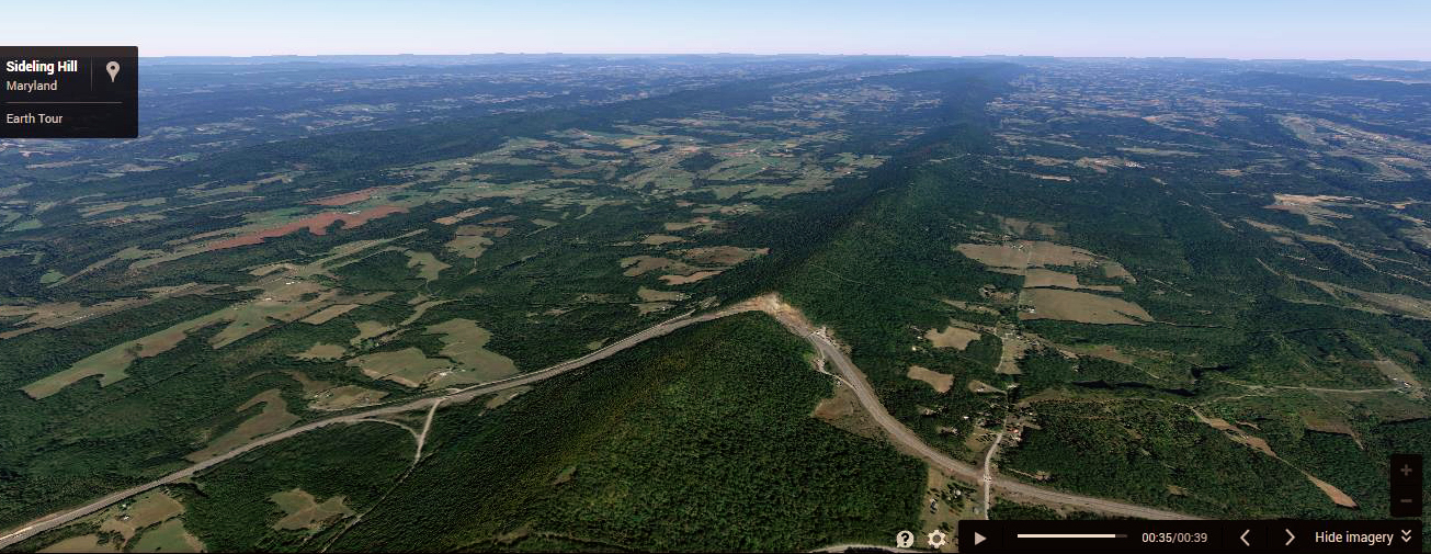
The road cut through Sideling Hill in Maryland on I-68 is one of the best displays of roadside geology east of the Mississippi River. Having spent considerable time in the western US it doesn’t seem that impressive to me but since I’ve been deprived of seeing geological strata for the past year I took a little detour on our family trip to North Carolina to check this road cut out. With the rest of the family sound asleep in a small hotel in Hancock MD I slipped out at 5 am on a brisk June morning to catch the sunrise at Sideling Hill on Interstate 68.
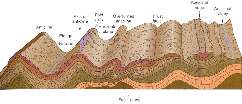
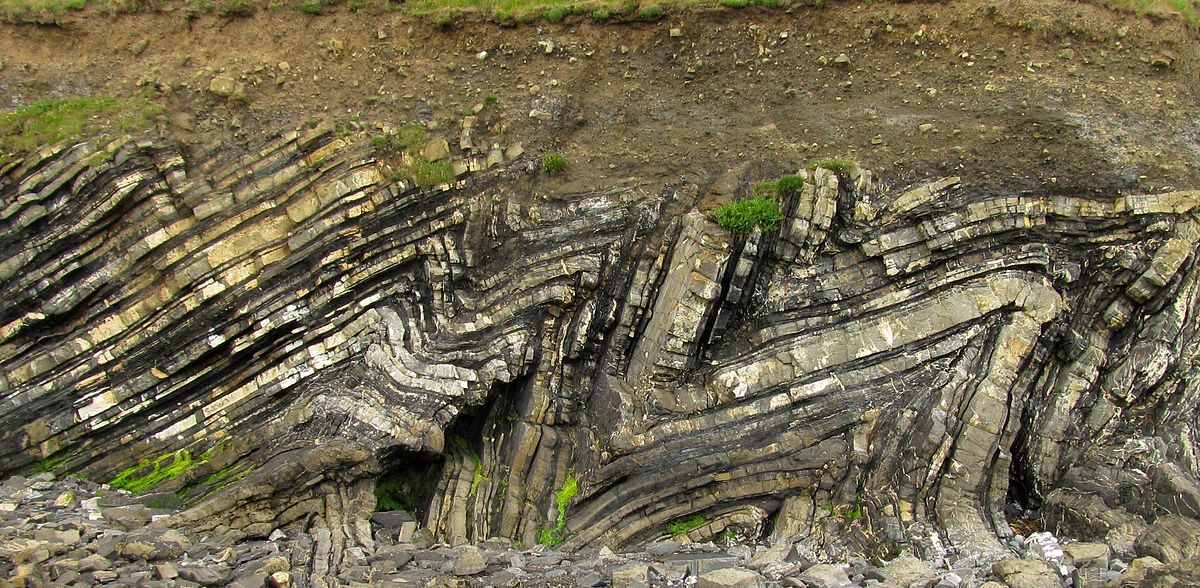
Yes, rock does bend. There are hundreds of layers of rocks here that must have originally been the result of horizontal deposition. The layers of coal, sandstone and shale rocks here would have become solid while still horizontal and them were slowly warped by constant pressure and heat over long periods of time. On display here are over 800 feet of strata in a folded syncline. The long mountain ridge that is Sidling Hill runs North and South and is the result of an erosion resistant sandstone layer at the top of the ridge. Below is a diagram of various ways that rock can be folded. Sideline Hill is most like the synclinal ridge.
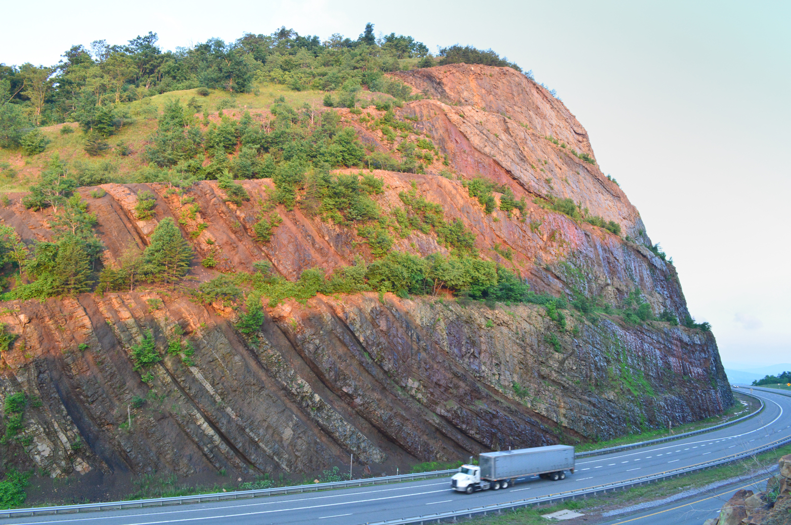
Here the sunrise is just hitting the top of the south side of the road cut. I took the picture with the truck for scale.
The bend in this rocks would have formed from millions of years of compression while there were still hundreds or thousands of feet of rock still on top of these layers. As the horizontal layers folded they also were eroding. Eventually the entire region saw thousands of feet of rock erode leaving many ridges like this one and hundreds of others in the MD/PA/WV region. It might be tempting to think that these layers bent very soon after they were formed and were still soft but as intuitive as that may feel there is no evidence to support that. Soft layers would have mixed rather than bent. If all these layers were somewhat soft when they bent why would they have suddenly become rock shortly thereafter? The erosion that occurred to this area to produce these ridges makes sense only if all the layers were solid rock as the layers were bent. You might think that rock would shatter rather than bend. These rocks are full of billions of very tiny stress fractures but much of the rock is truly bent due to the enormous pressure placed on them over time (see this article on plastic deformation for an explanation). However had they been bent quickly – say in a hundred to 100,000 years – then those cracks would be far more significant and complete rupture of the layers would have occurred.
For an excellent discussion of folded rock and its implications read this post from Questioning Answers in Genesis: Rock Layers Folded not Fractured, or are they?

There is pedestrian bridge that crosses the interstate on the east side of the road cut. There is an opening in the fence so you can take a picture here. You can very easily see the U-shape bend to the rock layers here. The very top layer in the middle is a hard sandstone that is resistant to erosion contributing to the formation of the long ridge.
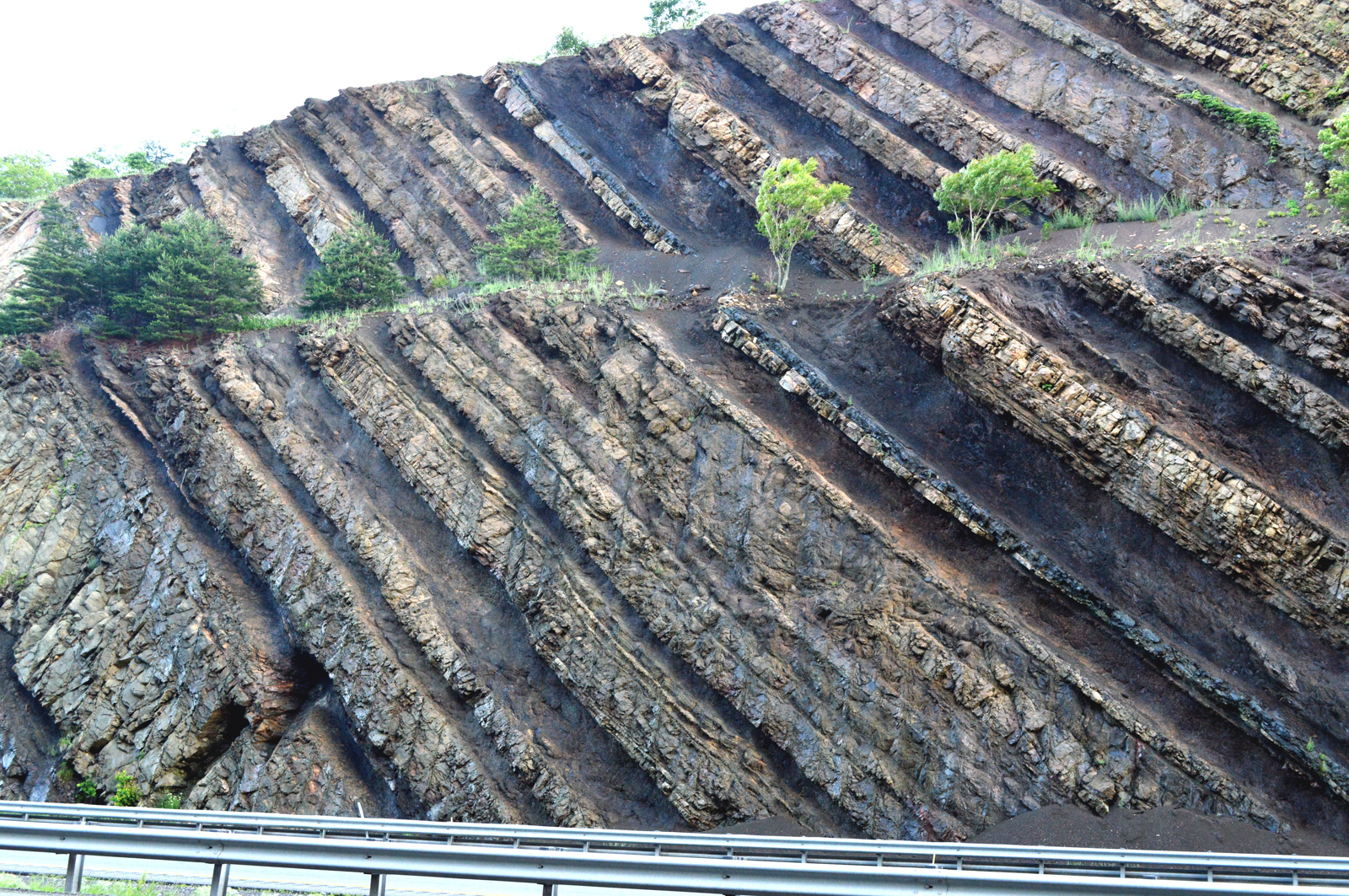

Above and below show the alternating bands of shales and sandstones. The darkest bands are organic rich coal seams.
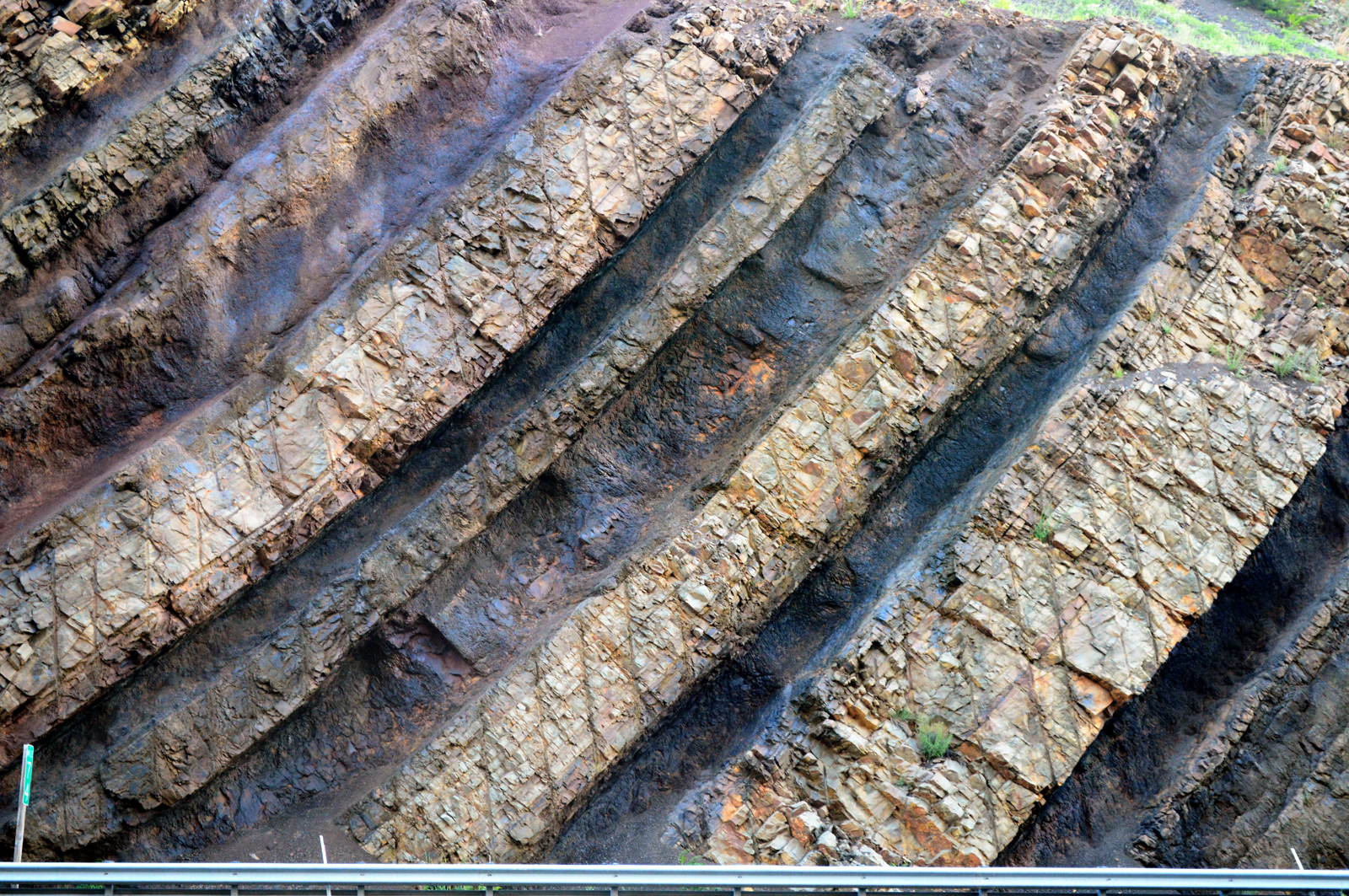

On display in these layers or rock are a record of a changing environment from wetland to shallow seabed and back over long periods of time.


nice. Reminds me of layered rock I saw near San Sebastian Spain.
LikeLike
You write: “Yes, rock does bend.” — What are the citations to the studies which support this assertion?
LikeLike
I’d consider it common knowledge among any geologists and enthusiast but since the blog is more for the lay person some citation might have been helpful. Just go to Google scholar and look up “rock deformmation” or “rock folding” or “folded strata” and there will be an abundance of references. Most are from the 1960 and 1970s. Much work both theoretical and experimental was done to understand the physical processes. There is nothing about the chemistry of these rocks that would suggest that they cannot bend over long periods of time especially under higher heat but that isn’t even necessarily in many cases. We call rock solid but all the molecule bonds are subject to swapping under pressure. Not that most folded rock isn’t fractured, as I said, there are billions of small fractures in these layers or rock.
This paper is one example. This one lays some theoretical groundwork for testing the elasticity of rock based on known chemical properties and finds that tectonic folding withing established geological timescales is very reasonable: Theory of folding of stratified viscoelastic media and its implications in tectonics and orogenesis.
http://www.pmi.ou.edu/Biot2005/papers/FILES/090.PDF (full text)
http://gsabulletin.gsapubs.org/content/72/11/1595.short (abstract)
This paper is from 1961. Morris should have been familiar with this work and many others published at this time but doesn’t seem to have taken it into account in his work.
LikeLike
You lost me regarding your reference to “Morris”. Is there some other citation by someone named Morris?
LikeLike
Sorry, I meant Henry Morris who wrote The Genesis Flood in 1961. He would have argued that all the folded layers of rock today are the result of tectonics during the global flood and thought that they layers had to be soft to be folded.
LikeLike
Well before Henry Morris’ time, George McCready Price argued that folding occurred while the rock layers were still soft… Price, G. M., 1923, The New Geology, Pacific Press Publishing Association, 726 pp., see p. 691.
LikeLike
I really love the photography here! These are some really gorgeous pictures.
Regarding YEC and the Flood, I genuinely wonder how it is that the Flood is supposed to have deposited layers like this. How could an exposed layer of rock be folded like this? After all, the Flood explanation is that it pulverized the rock and let it settle down so that it could have folds like this as it settled. But then how did it get sideways? How did it turn at all? It doesn’t seem to make any sense
LikeLike
There is a really good article on this: http://questioninganswersingenesis.blogspot.co.uk/2011/04/rock-layers-folded-not-fractured-or-are.html
LikeLike
Thanks for that link. I should have included it in my post and will go back and edit it in there. I had forgotten about this excellent post but I am sure that I had it subconsciously in my mind as I was taking these pictures.
LikeLike
Nice photo essay! I live in PA but travel in the Northwest for work. Driving around WA is a thrill, of course, since the geology east of the Cascades is “naked” – very exposed due to the lack of vegetation. It’s more of a challenge here in the East, so roadcuts are a unique window into the geology of the region. I recommend the series, “Roadside Geology” (find them on Amazon), as nice guides to the geology you may be passing on car trips. They are organized by state and give you a great introduction to the geology of the area, give you landmarks to look for and often dissect roadcuts like the one described here. I used to keep my copy of the PA edition in my vehicle when I was going long distances on Rt 15, 81, or the PA Turnpike. Once you have one of these, the challenge will be to keep your eyes on the road!
LikeLike
Another thought: For those who are beginning to explore geology and earth history outside of the young-earth paradigm, resources like Roadside Geology can provide some much needed local perspective, helping people understand, maybe for the first time, something about the literal ground beneath their feet. Not everyone has an opportunity to tour the Grand Canyon, hike around Mt. St. Helens, or find much relevance to cross-bedded sandstone or island arcs. Learning the standard geology about the place/region you live, however, can be the key to understanding the explanatory power of that model and highlight the shortcomings in YEC/Flood explanations.
LikeLike
I drove through this formation this weekend and immediately wondered about the geology…sure enough, here it is!
LikeLiked by 1 person