How could anyone not be curious about Mars Curiosity rover? NASA gambled by playing up the “7 minutes of terror” landing, using social media very adeptly to get a huge audience right in the middle of the Olympics. Failure of the rover to safely land surely would have been a crushing blow to the planetary exploration program. In the end the gamble paid off. The rover landed safely and has already sent back images which give us a new view of the planet Mars. For many the technological achievement of the landing probably is the

last thing that they will remember about the mission, as if the purpose was to just show, once again, we can do something really really hard. For example, predicting the landing to fractions of second weeks ahead of the landing and then having the real landing come within a second of the predicted time just boggles the mind! For many, the results of the actual research on the planet will probably seem anticlimactic especially since NASA, and mostly the popular press, has played up the goal of the mission as a search for signs of past life. I suspect that the chances of finding that are far lower than the chances of the rover landing safely on the surface. But there is so MUCH more to this mission than finding the smoking gun evidence of past life which itself would just raise more questions rather than answers but I will get to that in a future post. The rover has its wheels on the ground and its going to be fun to see the data stream in over hopefully the next several years. Starting with the Viking lander and then a number of satellites in orbit and rovers on the planet our understanding of the history of Mars has gone from speculative hypotheses more and more refined hypotheses of the origin of its surface and particular land forms. Each rover has encountered similar but different geological features which have been added to the complexity of our descriptions of Mars geological history. The rover Curiosity has landed in a particularly diverse geological landscape for which the study of the diversity virtually guarantees to change and improve our understanding of Mars geology even if it doesn’t tell us anything about past life on Mars.

A geological history detective?
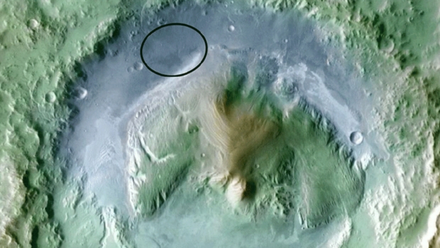
What do I mean by this. The rover has landed inside a large crater on Mars. The image above shows the general targeted landing area which Curiosity did land in. From there the rover will be able to investigate the rocks of the relatively flat crater floor and then look at what, from satellite images, to be layers sedimentary rocks at the base of the mountain in the center of the crater. There are some guesses as to how these layers were formed which I won’t go over here but the rover should be able to provide a large amount of data which will allow investigators to form and test hypotheses about the origins of these landforms. Given some of my past comments on the Mars geology (Apparent Age: Craters on Mars) and (Perceptions of Age: Craters on Mars) and its implications for the age of the earth and apparent age arguments it is tempting to talk about young earth creationists responses to Curiosity but I will save that for a separate post. For now let me just preview what Curiosity will be looking at and what sorts of data it can collect to shed light on their origins.

Diversity of rocks suggests a complex and ancient history
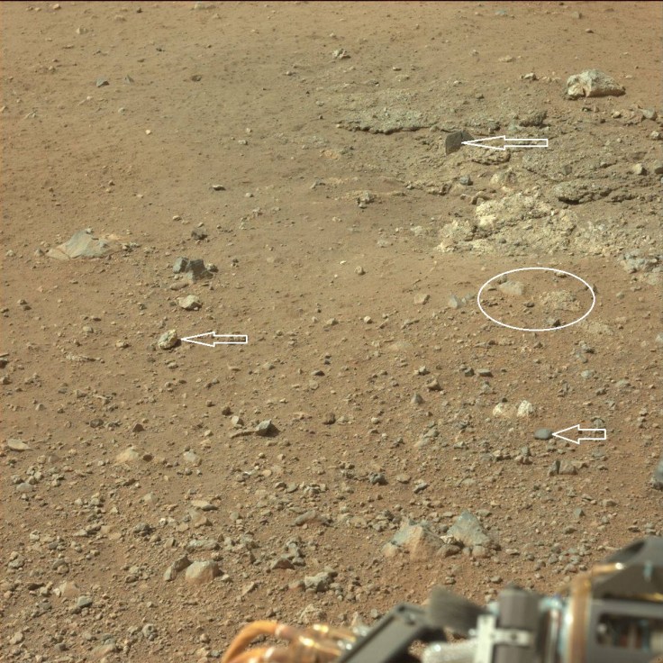
The above image shows the immediate ground around the Curiosity rover. The rovers wheels barely made a dent in the surface suggesting that the sandy/rocky surface is either very stiff of us underlain with bedrock very close to the surface. What you will notice right away is that the rocks strewn across the surface are definitely NOT all the same. They differ in reflectance, shape, and texture. This is more diversity of rocks than has been seen elsewhere on Mars although the Spirit rover did see several different rock types in its travels. Here we see rocks with smooth surfaces and others than are fairly jagged. Right away this suggests that the rocks at this location were formed in several locations and somehow ended up mixed up together right here. Smooth rocks likely have different compositions and/or been exposed to wind erosion for longer than jagged rocks. By examining the rocks composition which this rover will be able to do with several different instruments much better hypotheses can be generated about the origins of these rocks and how long they have been exposed at the surface.
Another feature apparent in the area where the rockets scoured the surface clean is that there is a form of rock that seems to make up some type of bedrock just below the sandy surface but this bed rock (upper right above) appears to be composed of smaller pebbles that are cemented together and there also appears to be a larger rock (arrow, upper right) that is imbedded in this hardened material making it something like a conglomerate. Conglomerates on earth are the result of rocks formed in one location transported and mixed together and then cemented together to form a combination rock. So just this site in the immediate ares of the rover already suggests a complex history. This is the floor of a large crater which when first formed would have been far deeper and then filled with debris eroding from the sides walls of the crater or blown in or thrown in from other impact ejections in the area. That material could have been cemented together especially if water were present in the past. Erosion of that material by the wind and new material thrown onto the surface could give it today’s appearance. But this is only one type of geological formation and there are many others to explain.

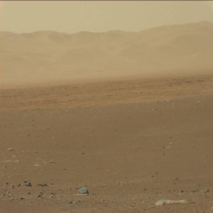
The image above looks out toward the Gale Crater wall rising thousand of feet above the floor of the crater. In front of the hills and mountains you can see very clearly (especially in the larger image) that there are many thin layers of darker rocks/sediments that appear to represent layers a bit higher than were the rove is sitting now. Then there is a higher plain that is not eroded as much. The composition of these layers will be interesting because just like on earthy layered rocks represent a series of historical events. By looking at the chemistry and size of the particles that make up each layer, the events responsible for their formation can be determined. Where the layers formed in water or by wind or some other process (this lava flows)? The particle size, composition, and if the particles are smooth (been exposed to wind or water for a long time) or have sharp edges (maybe debris rained down from rocks thrown up from a meteorite impact) will go a long way to determining the answer.

Above we see the primary target of the Curiosity rover. In the distance is the base of the mountain that rises from the center of Gale Crater. The dark regions have been identified as sand dunes by orbiting satellites. Obviously the sand has a different composition. Even in this sandy region there looks to be layers of rock that have eroded differently which tell us that the composition of those layers is not all even. There are many layers of rocks in the hills above those dunes that from orbit have been shown to have different chemical compositions to those above them. Curiosity will be able to study these in much greater detail.

I suspect that some people will see the pictures of Mars and think that they all just look the same but on close inspection at multiple sites now it is apparent that there is quite a bit of diversity in geological formations. I admit that this particular location really boggles my mind when I try to think of a scenario of events to explain all of the features just seen these few pictures. Given today’s very dry, thin atmosphere with light winds it is very difficult to explain these features. Past conditions could have been very different which is part of what Curiosity is designed to explore. By examining the sediments and rocks Curiosity will help us better predict what past climates were on Mars and thus help us to build a better picture of how these formations have come to look they way they do today.
How long in the past were conditions different? How long have the rocks right in front of the rover been exposed at the surface? Those are difficult questions to answer right now, but as a teaser I would thrown out there is that the Opportunity rover has been on Mars for 8 years and the first wheel tracks that it made on the sands of Mars are monitored by satellites and they have as yet not shown any changes during that time. If that rover came back to where it first landed and took a pictured it is likely that every rock would look the same as it did 8 years ago. Today the surface of Mars is barely changing. A question raised by the geology of Mars is if one were to travel back in time 100, 1000, 10,000, 100,000 years or even 100 million years and took a picture of the surface from exactly where Curiosity is standing today how different would those pictures above look? I will explore that, and the implications of the answer in a future post.