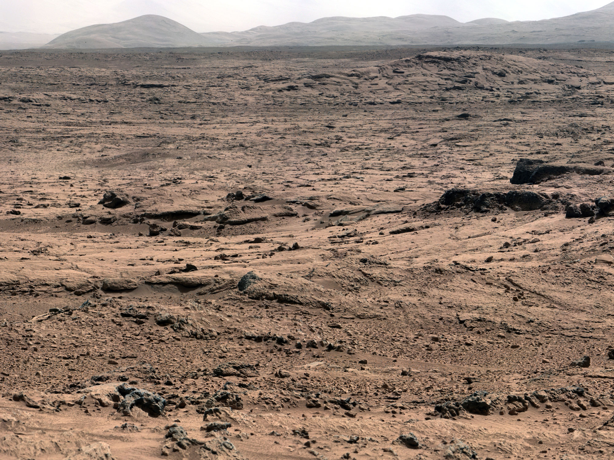
Large depressions, layers of rocks, precipitated minerals in rock cracks, erratic rocks strewn about, mountains inside of craters: these are just a few examples of the diversity of landscapes on Mars that the Curiosity rover has discovered and been investigating the past six months. The mountain at the center of the crater that Curiosity has landed in has been of special interest to those that sent the rover there and discussion about its origins has been quite lively. I suggested in an earlier review of the Curiosity rover landing and first images that there were several hypotheses for the origin of the large mountain that is in the center of the crater (see: Diverse Geological Landscapes Found on Mars). Its origins have fascinated geologists because it is an unusual land form on Mars and has apparent layered rocks or differing compositions. The latter strongly suggests this isn’t “rebound” rock from an asteroid collision but rather a feature that has developed over time. But how? Did the entire crater fill with sediments and then a ring of that sediment get removed over time leaving a mountain behind. Or maybe there has been ice buildup and dust accumulation in the center due to the winds just inside the rim of the crater. The Curiosity rover was sent to this rover to possibly provide an answer and in hopes that at least the lower layers of this massive mound originated in a watery environment. If all the features inside this crater can be explained by the forces of wind and erosion then the types of discoveries to be made will be deemed as not nearly as interesting. I have said before that I fear that scientists have put far too much emphasis on finding conditions that would be conducive to past life creating the perception of failure for the mission should they not be found. But, the geology is fascinating in of itself and the ability to study geological processes on another planet up close and in detail has already yielded many new insights into how Mars was formed.

With respect to this 1500+ foot mountain that sits in the middle of this large Gale Crater a manuscript that I referenced last year has finally made it through peer review and was published yesterday. When I read the draft of the manuscript last year I found the evidence for the wind/ice origin of Mt. Sharp to be quite compelling. Here is what I wrote earlier, with a few edits, about their explanation of this mountains origin: The authors examine the layers from images taken from orbit and they hypothesize that aeolian (wind) processes are the primary causative agent of Mt. Sharp’s formation. Using modeling of wind velocities and information about past climate changes they suggest that the rock layers that are observed are not the result of deposition in water but rather are the result of many thousands of repetitions of ice ages on Mars combined with down-slope winds in this large crater. How this would work is that when the climate changes on Mars due to the known and measured wobble on its axis of rotation (the Earth also wobbles causing changes in climate over time) water from the poles released and builds up in the form of ice a lower altitudes. There is a growing body of evidence that there was large patches of ice much further south than seen today. It is proposed that ice formed primarily in the center of the crater and then dust got trapped in that ice and deposited on top of it. When the climate changed again and the ice sublimated back into the atmosphere the dust layer would be left creating a layers of new soil/dust. At the same time it is also possible that some water melted and then leached chemicals down into the lower layers of the sediments resulting in the different chemical profiles seen today. The main point is that successive “ice ages” would have resulted in the pancaking of many many layers of dust on top of one another resulting in the layering of sediments. Depending on the source of the dust wand what other formations were eroding at the time, the dust would have different chemical signatures. At some point the wind patterns of Mars may have changed and the ice ages may have differed in their intensity causing the dust and layers to accumulate in a different pattern resulting in the unconformity. How long would this take? These “ice ages” are thought to have come and gone every 5 million years or so as predicted by the wobble of Mars over time. If each layer represents one of these ice ages then the mountain represents hundreds of millions of years of development if not a billion years or more of growth.

This dusty origin wouldn’t preclude the possibility that there was a lake in this crater prior to the mountain forming. In fact, Curiosity has provided abundant evidence already of the presence of water in the rocks and probably free-flowing water on the surface at the location it now stands. The lower layers of Mt. Sharp appear to bear the molecular signatures of having been formed in the presence of water but it has been known even before Curiosity arrived that most of the rock layers may not have been formed in water. The wind/ice build-up theory helps to explain why many of the layers of rock that make up the mountain do not appear to be horizontal as you would expect if they had all formed at the bottom of a large lake. The Curiosity rover will be able to provide tests of these wind-formation hypotheses as it collects more information about the rocks and the weather patterns inside this crater.
References:
http://arxiv.org/ftp/arxiv/papers/1205/1205.6840.pdf This manuscript was submitted article last year. This shows how modeling was used to suggest how mounds could “grow” in the center of craters by the action of wind vortexes and successive ice layer growth and retreat. Growth and form of the mound in Gale Crater, Mars: Slope-wind enhanced erosion and transport. By, Edwin S. Kite, Kevin W. Lewis, Michael P. Lamb. This manuscript has now been published after peer review and the abstract can be found here: http://geology.gsapubs.org/content/41/5/543.abstract
R. E. Milliken, J. P. Grotzinger, and B. J. Thomson. Paleoclimate of Mars as captured by the stratigraphic record
in Gale Crater. GEOPHYSICAL RESEARCH LETTERS, VOL. 37, L04201, doi:10.1029/2009GL041870, 2010
Thomson, BJ, NT Bridges, … and GM Marion. 2011. Constraints on the origin and evolution of the layered mound in Gale Crater, Mars using Mars Reconnaissance Orbiter data. Icarus, Vol 214 (2). 2011. PP 413-432.
http://arxiv.org/pdf/1102.0868.pdf This is a submitted manuscript by Brasser, R and KJ Walsh. 2011. Stability analysis of the Martian obliquity during the Noachian era. Astrophysics.
ORIGIN AND EVOLUTION OF SEDIMENTS IN GALE CRATER THROUGH ICE-HOSTED PROCESSES. 2012. P. B. Niles1 and J. Michalski. 43rd Lunar and Planetary Science Conference (2012)

I see AiG are talking about Mars too (item 1):
http://www.answersingenesis.org/articles/2013/05/11/news-to-note-05112013
LikeLike