Family vacation with the Duffs always includes some geological sights. In 2007 we visited Prince Edward Island and had a wonderful time but the there just wasn’t enough geology there to satisfy my curiosity so I took us on a 2 hour detour in Nova Scotia. After a lot of “are we there yets” and some rather average terrain and small towns we arrived at the Joggins Fossil Cliffs on the Bay of Fundy. I think the kids will remember the place for a long time. Not so much for the fossils and cliffs but for the dramatic tides. Low and high tide are the largest in the world. Here you can see a change in water levels in the bay of around 50 feet in the space of just 6 hours. We got there just about low tide which I had planned. During our hike along the cliffs we saw the tide come in many hundreds of feet. It felt as if it were chasing us back up the rocky beaches (see pictures below)
But enough of the tides, they were just the distraction to get the kids to stay longer, I was interested in the rocks and fossils. The Joggins Fossil Cliffs are now a World Heritage Site because of their significance in the history of fossil collecting and interpretation and even their present day significance as the best representation of Pennsylvanian-aged rocks and fossils in the world. Geologists and naturalists have traveled from all over the world since the 1800s to visit this site and interpret its rocks. I wanted to see it because I had read about it many times and also because it is often discussed in creationists literature. This is the site of the famous polystrate fossils (trees standing on end preserved in rock) that young earth creationists point to as evidence of a great Flood. I wanted to visit the site personally because I find that without context and a feel for the rocks themselves it can be difficult to assess theses claims.
My one big regret from the trip is not taking more pictures. I always feel like I am taking quite a few but now that I look back I wonder why I don’t have more. Below I take you on a brief tour of a small part of the Joggins Fossil Cliffs and provide some simple explanations for what you will see.
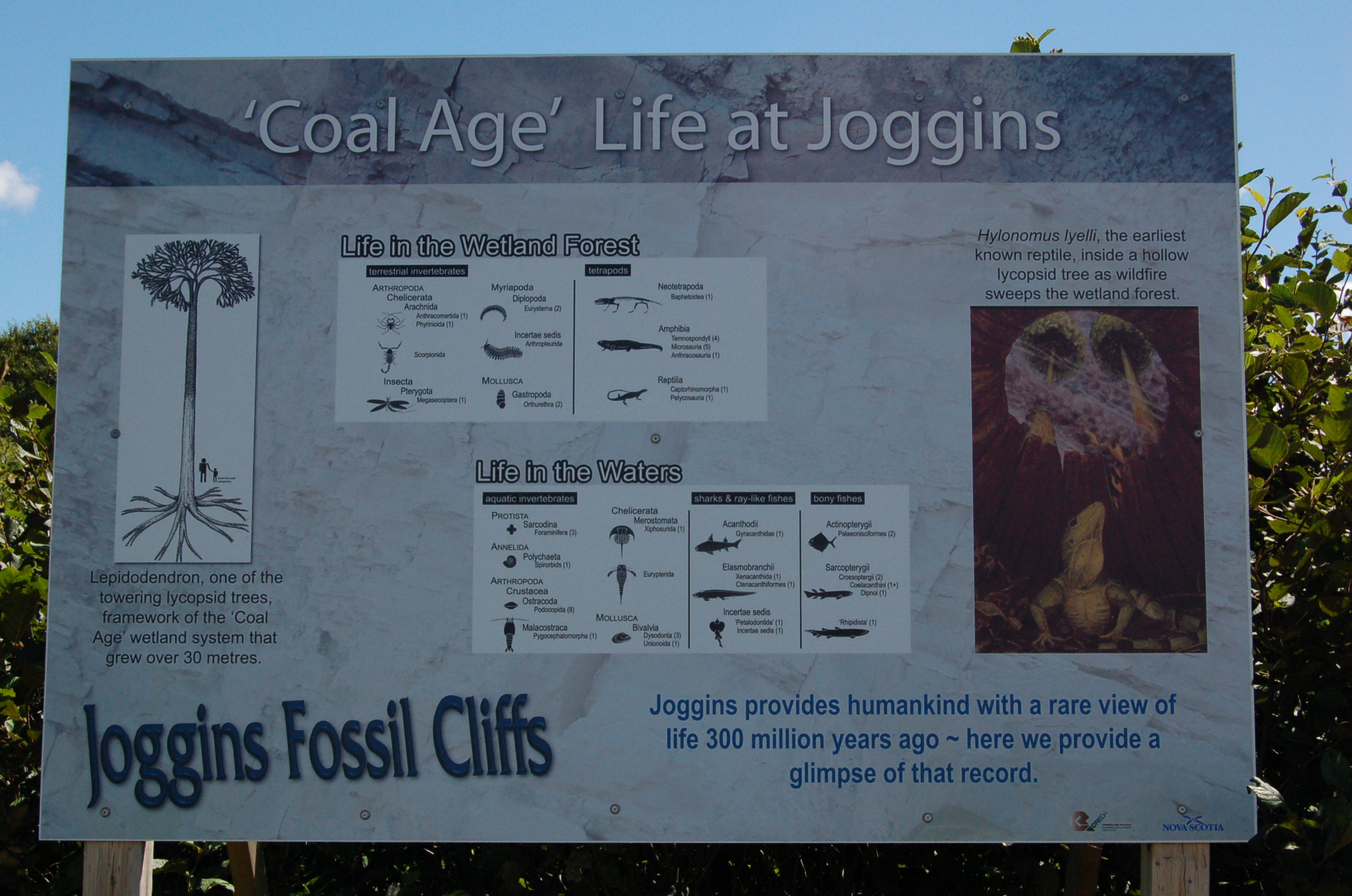
First, we come to a sign that was posted on the trail down the cliffs to the beach. I show this pictures because it gives a quick summary of what fossils are found in the cliffs. You have probably scene images in a book of “life in the coal age” or Carboniferous period. The images show a strange world of weird looking trees, lots of large and bizarre-looking insects and a few amphibian and reptile-looking creatures. There are NO flowering plants, birds, or mammals in these dioramas. What inspired these images – The Joggins Fossils Cliffs. The same types of organisms are also found in many other places in the world were there is rock of this age but this is the best place to see these. There are millions of fossils along 15 kilometers of cliff-lined beaches and all of the fossils that have been looked at by hundreds of experts and tens of thousands of novice fossil-hunters are all of just these types of organisms on this sign.

Three of my kids are in the distance and they would in several feet of water at high tide. By the time we left the water was almost to where they are now compared to when this picture was taken near low tide. Here we get our first glimpse of the cliffs and the many layers of dipping rocks. The redish layer of rock above was deposited sometime well after the other layers were formed, got tipped and eroded.
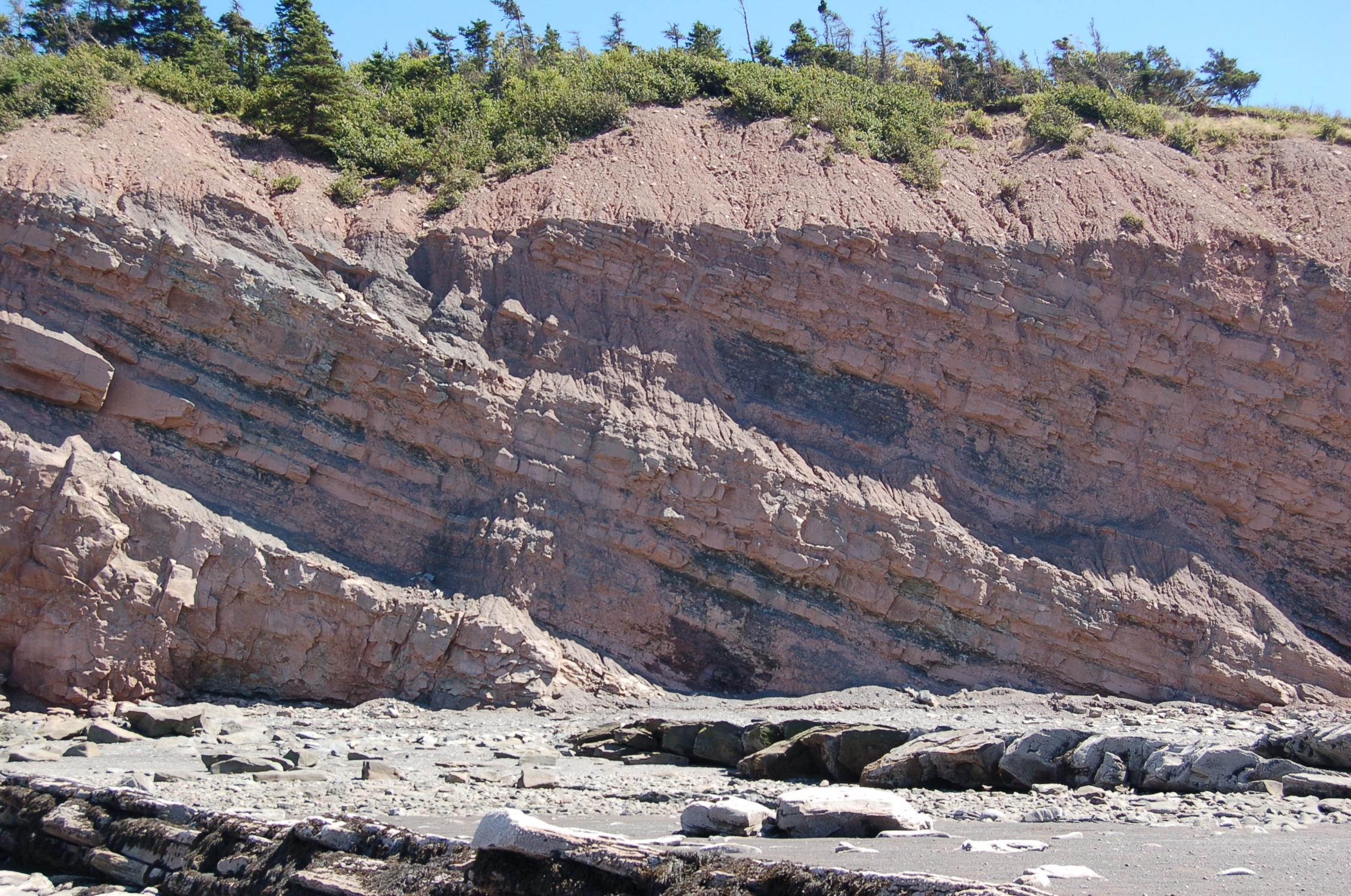
Here we see more closely the many layers of rock with darker coal seams between lighter colored sandstones. On top of these layers is something called an unconformity in geology. The red rock sitting on top could not have formed at the same time as the other layers. The redish material is horizontal compared to the material below which is at about a 40 degree angle. All these layers of cliffs must have been deposited originally as horizontal layers. After they solidified into rock the entire area must have been uplifted to the north or depressed to the south (or both) resulting in the dip in the rocks that we see today. Then there was erosion that resulted in this whole area being flattened off before new sediments were deposited on top which then became the rocks we see today.
The coal seams are interpreted to have been the result of marshy swampy areas that were inundated by rising sea levels which then covered them with sandy material. Later when the sea level went down trees again grew in the shallow water causing more organic layers to form. This cycle is thought to have repeated over and over again resulting in the bands of coal that we have today.

Wow, now that is a lot of layers or rock. I am taking this picture from a point where many pictures of the Joggins Fossil Cliffs have been taken. Notice the straight lines of rock in the foreground. These are the layers of rock from the cliffs that extend out into the bay. The hardest layers don’t erode as easily as some other layers leaving these ribbons of rock poking up on the beach.

I noted before that it is thought that these layers of rock were the result of shallow water swamps and rising and falling water levels. One of the evidences for the swamp and lake interpretation is the very common occurrence of ripple marks in the rocks. These ripples would have come from a shallow slow-moving water flow of a wide river or very shallow beach extending over a large area.

More ripple marks. I took pictures of about 10 rocks that showed evidence of preserving past ripples but this was only a very small sample of the thousands of rocks that are this site that show evidence of ripples. The ripples are highly varied but what is interesting about them is that detailed studies of ripples like these can tell an investigator much about the habitat because the grain size of the rock can be used to predict the speed and depth of water that produced the ripples.
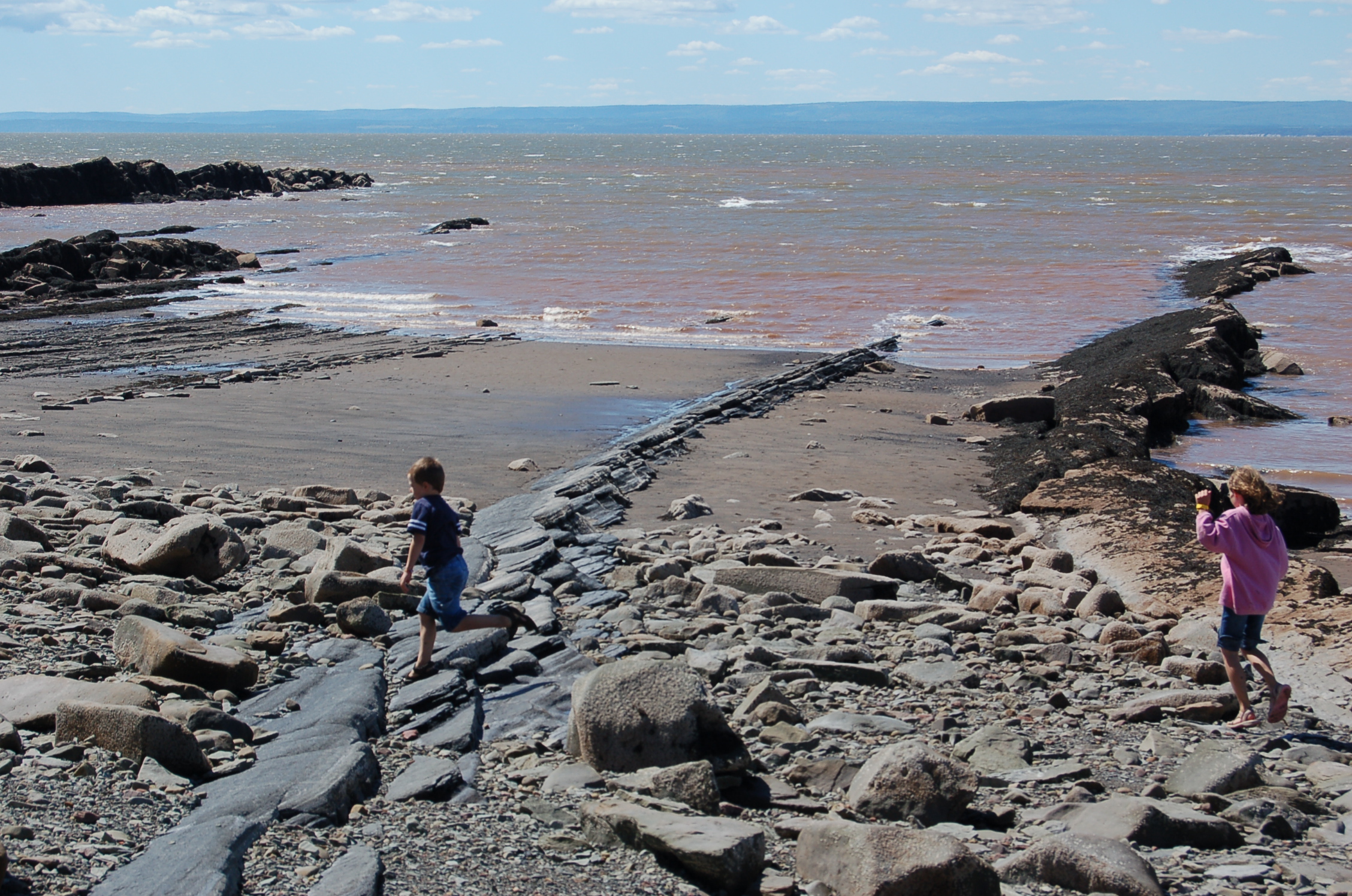
The tide if coming in! Each successive wave brought the water further and further up the beach. Graham is running across a well-worn coal seam. Ann just came over a very resistant layer of hard sandstone.
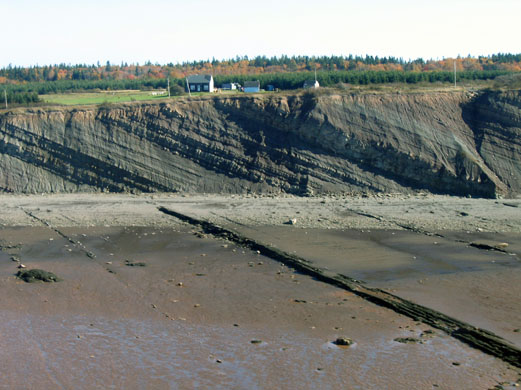
This picture to the right is not mine but is a good shot of the long beach and the cliffs with beautifil angled layers of rock. What brings people back to this site is that the cliffs are always eroding and so there are always new rocks and new fossils on the beach below. This picture also shows how flat the land is above the cliffs.

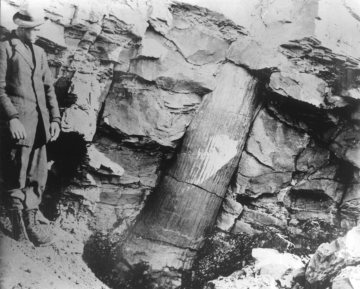
The polystrate trees that may be the best known fossils are all the same type of extinct tree called Lepidodendron. The picture above shows a fossil of its roots. I say many many rocks with impression of the roots and traces of smaller side roots. I also saw many rocks with impression of the branches and stems of the same plant. As you walk for a mile along the cliffs you see the same plant impression over and over and over again with no variation. You get the distinct impression of a huge area that must have had just a few closely related type of trees.

What is not discussed by some that focus on the polystrate trees is that the entire area (hundreds of square miles) has rocks that are full of remains of these plants to the exclusion of any other types of plants. I mentioned right at the top of this post that no flowering plant fossil has ever been found here despite thousands of people having looked for fossils in this area. The roots, stems, and reproductive structures are all from extinct groups of plants called lycophytes and some ancient ferns.
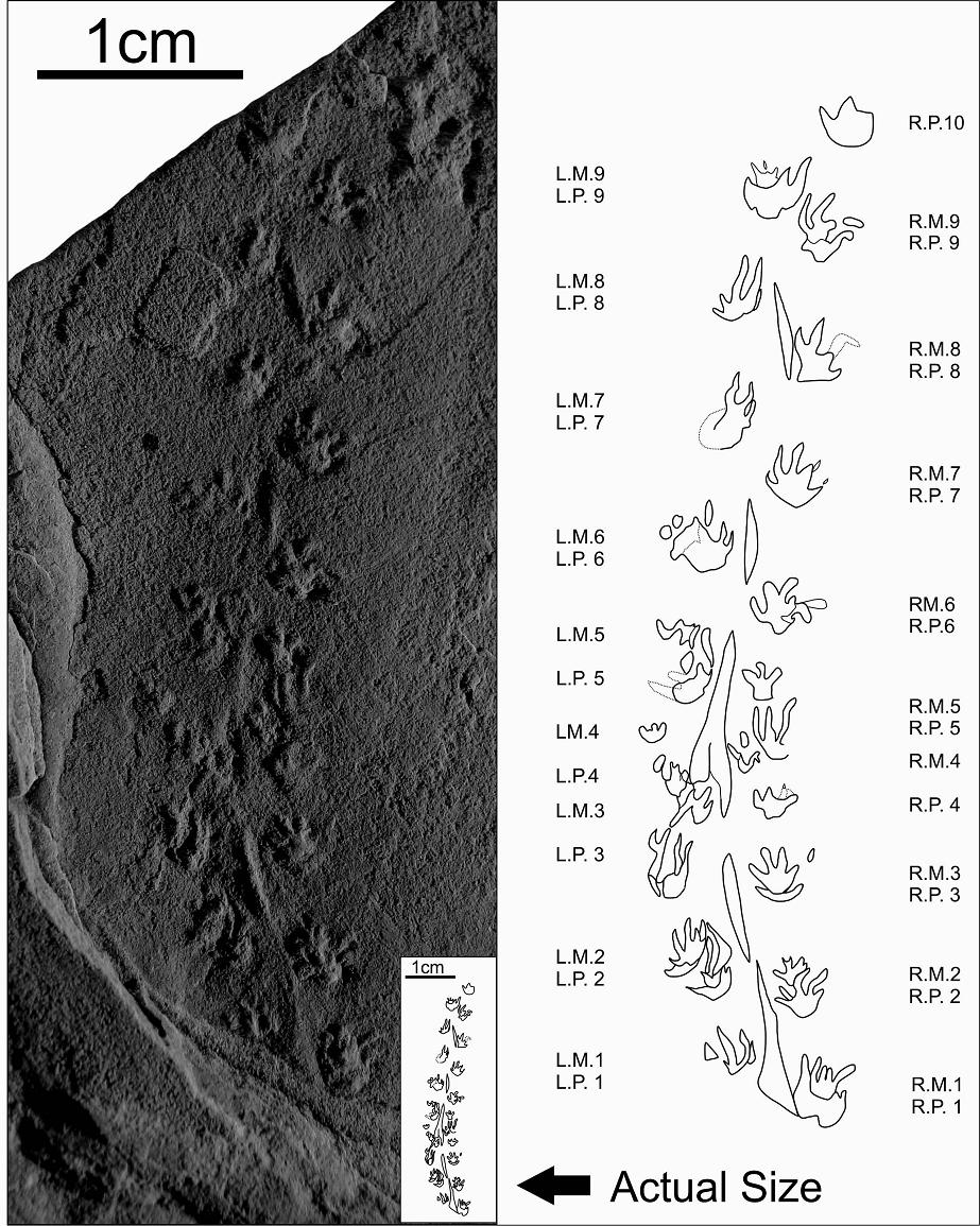
It isn’t just the plants that are famous at the Joggins Fossil Cliffs. More evidence that this was a shallow water swamp, lowland forest and/or delta region prone to flooding is the presence of thousands of tracks of small amphibians, small reptiles and even giant millipedes. The above image is from a report last year of the smallest known tetrapod footprints in the fossil record. This small set of tracks was found by an amateur fossil hunter walking along the same beach that we walked in 2007. In addition to the track-ways many fossils of a salamander-like amphibian and small reptiles have been found here. The tracks that are found in these layers are the types of tracks that one would expect that the same organisms to make. The presence of fossils plus track-ways suggests that there were organisms living with the plants that are also preserved here.
Implications of the Joggins Fossil Cliffs for Young Earth Creationism
While creationists talk a lot about the standing tree fossils I have never heard them talk about any of the other fossil nor have I heard them talk about the geological context of the site. The presence of thousands of small track-ways, amphibian fossils and remains of all of the part of the same trees in this area strongly suggest an ecology in which these where the only organisms present at the time these sediments were laid down. YECs would have all of these rocks laid down in a short (hours to days) period of time. They point to the trees in place as evidence that it must have happened very fast. But what about the tracks of very small animals and the preserved ripple marks? Why are there no flowering plants fossils? Why no pollen from any trees or flowers? Why is there only type of tree found here and why is it that on every continent there are rocks that contain these same combinations of plants and animals? The polystrate trees are not that difficult to explain once you have really looked at the context. Inundation by local flooding over a period of months or even 10s of years is very reasonable and viable hypothesis to explain them. However, a cataclysmic flood that caused all these layers of rock to form in days has no power to explain the presence of only amphibians and reptiles to the exclusion of all mammals, dinosaurs, and birds and the lack of plant diversity and the presence of ripple marks and most importantly the many tracks of animals.
References:
STIMSON, M., LUCAS, S. and MELANSON, G. 2012. The Smallest Known Tetrapod Footprints: Batrachichnus Salamandroides from the Carboniferous of Joggins, Nova Scotia, Canada. Ichnos 19: 127-140.

Spectacular images.
LikeLike
Thanks. I really do regret not taking many more pictures but my excuse is that this was at the tail end of our trip and travel fatigue was setting in. I would have liked to have hiked much further along the cliffs but at the time my youngest was only 1 1/2 years old. You might wonder why I dont’ have a picture of my own of the polystrate trees. That was my goal but what I learned when I was there was that they are not common and the ones that you see from the old pictures are no longer there because they have eroded. As a result there aren’t many to see and I would have had to walk a long way to see any. It just goes to show that the conditions that produce such trees are not common but horizontal trees are much more common as you might expect.
LikeLike
What a wonderful experience for you and for the kids! I’m sure they will remember this. These images are fascinating. Makes me feel as if I were there in person.
LikeLike
This is just a short drive from where I grew up in Dieppe, NB. The guy who found Batrachichnus salamandroides tracks was actually a classmate of mine in my early school days, and is a trained geologist. When I was president of the Sir Hugh Fletcher Geology Club at Acadia University we took a group to Joggins for a field trip and everyone found it very cool! If anyone is reading this and wants to experience the best of the rapid tide changes in the Bay of Fundy, I’d suggest booking in a white water rafting trip on the incoming tide of the Shubenacadie River (http://www.shubie.com/) – so, so fun!!
I live in Australia now, but it’s nice to see some appreciation for the wonders close to home, even though my stomping grounds were referred to as “rather average terrain and small towns”! Haha!
LikeLike
pick point: you wrote “coal seems” not “coal seams.” Great post, I very much enjoy your blog!
LikeLike
Thank you and thanks for the correction. I have made the change.
LikeLike
What is the geology of the overlying red layer, and are there other places where the tilted Carboniferous layers are both underlain and overlain by horizontal strata? I’ve always thought that tilted strata sandwiched between horizontal strata are a particularly easy to conceptualize problem to the Flood model, yet a very tough one for that model to explain. Seems like providing examples of just that might be a potentially good topic for you to cover at some point.
LikeLiked by 1 person