Southeastern Utah has an astounding amount of sedimentary rock on full display. Between our stays in Silverton Colorado and Moab Utah we made a trek through this area. One day hardly does this area justice but what we were able to see was amazing. The sedimentary layers are best seen in the gorge of the San Juan River as it carves its way through a thick layer of hundreds of square miles of sedimentary rock layers that have slowly upwarped over time. Below is an image I captured from Google maps and then annotated with some places that we visited or were close to those I am going to show photographs of.

Bluff UT is just to the right of this image. We knew we were entering an area were we would be seeing the hard Navajo sandstone capping off thousands of layers of red sandstones when we came down into Bluff and stopped at the Twin Rocks cafe. Below is a picture of the rocks looming over the trading post (cafe was next door).

From Bluff UT we traveled through comb ridge through the valley on the right and then back up onto a relatively flat area as we drove down to Goosenecks State Park. One of places I wanted to take a picture of was a former channel of the San Juan River that had been cut off. Below is a close up from Google Maps showing this cut-off “gooseneck.” But I missed the small dirt road leading to this unique geological feature and there was road work so there was only one lane of traffic and I couldn’t turn around. Instead I will have to rely on a picture loaded onto Paramino of this feature.

Below is a picture of this former waterway of the San Juan. What you can’t see here is the San Juan River in a deeper channel running behind this central mound. Notice that the bottom of the canyon is filled in a bit over time so that it rounded with erosion. One has to wonder how long it has been since any water ran around this portion of the San Juan channel. If you click for the larger image you can get a sense for the size of some of the blocks are sandstone that have fallen from the top edge. The fact that there are not many on the bottom of this channel suggest that they do not fall very often as they are very slow to erode.

Just a few miles south we come to the intersection where we turned off to head to the Goosenecks of the San Juan State Park. If we had driven further south we would come to the town of Mexican Hat and then the State of Arizona. I took quite a few pictures here because there were spectacular scenes all around. The first image is looking to the southeast. Here we see a famous rock formation called Mexican Hat. In the background is the upwarped layers of sedimentary rock that have eroded quite spectacularly. Notice that the layers that sit under the Mexican Hat are parallel to the surface. The close proximity of many horizontal layers with sets of layers that are angled is what has mad this area famous among geology enthusiasts.

Below you are looking east at what is called comb ridge which is the part that looks like the zig-zag line here. These are layers or rocks that have been bent 45 degrees on their side and then eroded. This ridge heads north at least 30 miles.

The view to the northwest shows the layers of red rock that we would be seeing so much more of as we head up to Moab and then in Moab. This whole areas was once covered in the same rock but then eroded to leaving a few pillars of rock in place. This is similar to monument valley to the south. Eventually we would get up on top of those rocks and make our way north.

Below is a picture I took standing at the point overlooking the San Juan river as the Goosenecks of the San Juan River State Park. This is just an amazing sight! The thousands of layers of horizontal rock are eroded out by this winding river. I should note that we were fortunate this day as the weather was fantastic for late July. It was 95 degrees here but it could have been much hotter and mostly in the 80s as we traveled in this region.

Next we drove north on route 261. After driving across a relatively flat plain for 10 miles or so we reached the base of this long plateau and we drove up this winding dirt road to get to the top. The view was quite spectacular and the temperature noticeably cooler when we reached the top.

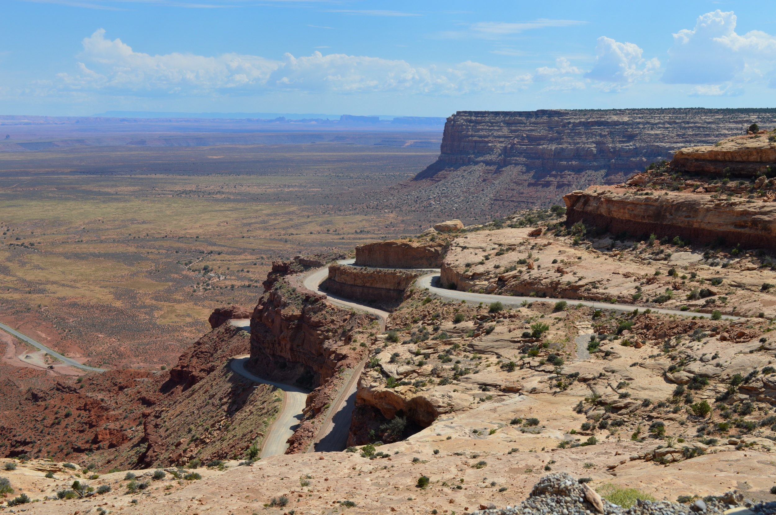
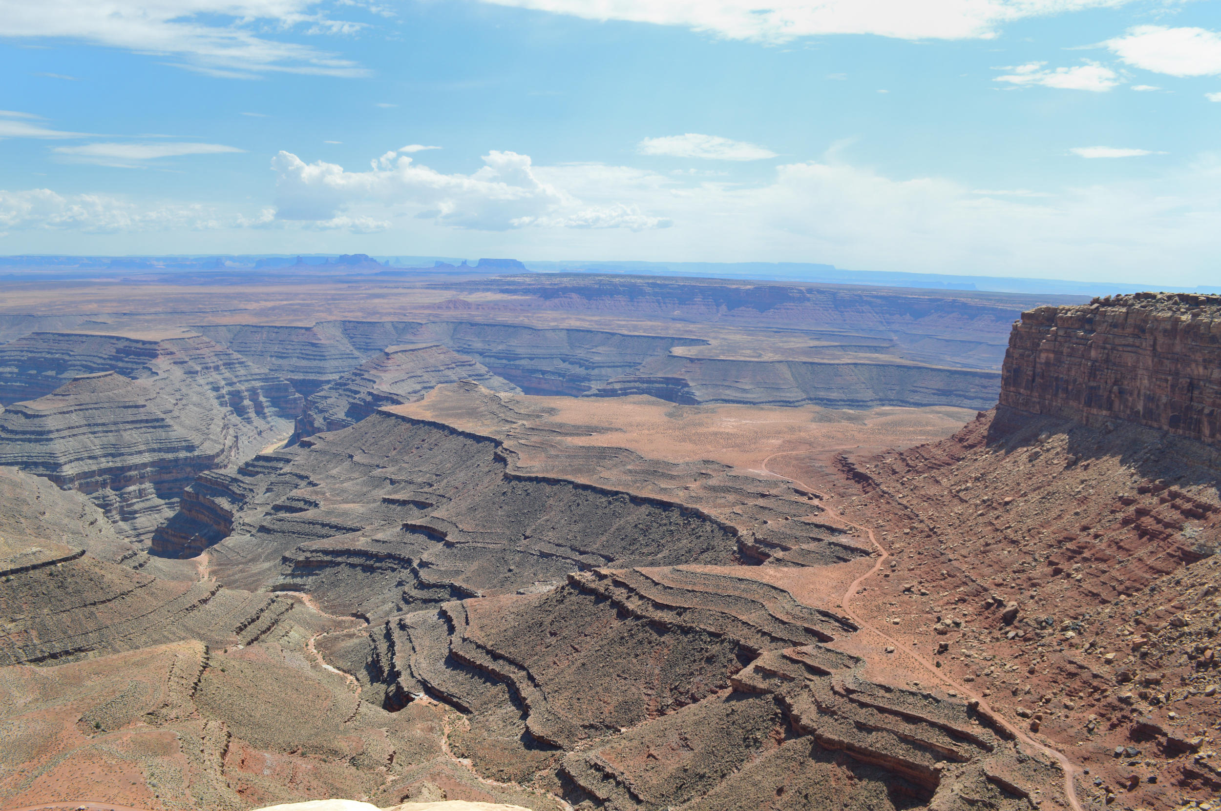
Rather than continuing on route 261 north we took a dirt road sound to the end of the plateau to Muley Point which overlooks the San Juan River area. We could look out over the area we had just visited from another 1000 feet higher up.

Below is the view looking toward the south from Muley Point. The road below is on a layer of rock that is more resistant to erosion and is the same rock that we were on when we were at Goosenecks of the San Juan State Park.
Off to Moab from here. More pictures to come…

You may have seen this: http://www.icr.org/article/7398/ (and this http://www.piltdownsuperman.com/2013/08/playing-slots-with-flood-formations.html).
LikeLike
Joel,
I know that you are a biologist, but how would you explain a cut off like the one pictured above on the San Juan? Mechanically, it seems a bit difficult to cut so cleanly with a river, especially since it’s not a shallow oxbow lake, but a much more significant (i.e., deeply cut) part of a chain of incised meanders. Anyone that has worked with wood knows how easy it is be diverted from your cut or carving by the slightest bump, rut, or channel in the material. So, when the river eventually comes back on itself, how does it stick to the channel so cleanly, especially over thousands/millions of years? I’m not a geologist either, though I had a few classes in geology and did some field work with Jeff Greenberg at Wheaton College a number of years ago. I have, however, since those years been drawn more and more to a global flood view, and I think that features like the one that you have pictured above point toward a catastrophic movement of water way beyond our imagining (just like deep time is really beyond our imagining, even though geologists throw millions of years around so readily). How would it be cut catastrophically? Perhaps it was incised by a massive underwater vortex that plucked the stones out of the channel. [This would be similar to the kolks that left potholes in the Channeled Scablands, but in the case of the San Juan, on a much larger scale and with much greater duration. In fact, something similar to this is being posited as one of the forces behind the formation of some of the deeper channels within English Channel, not by creationists, but mainstream geologists.] In short, it is really a matter of scale and perspective, and I am thoroughly convinced that the argument between catastrophists and uniformitarians (or actualists, as many of them would now want to be called) is far from over. In fact, the discoveries and discussions in geology really seem to be adding some real spice to the discussion even though many evangelicals, especially Bible professors in the academy, are doing vicarious penance and issuing mea culpas for their young-earth compatriots left and right.
Andy W.
LikeLike
Hi, yeah, I think it is only natural to find the origins of such a precise incision hard to imagine. Such cut-offs or “rincons” are also fairly common. One that is along Glen Canyon is just called “The Rincon” https://maps.google.com/?ll=37.311472,-110.78167&spn=0.213535,0.445976&t=h&z=12. It’s a question of fluid dynamics really and the entrenchment of a meander has all to do with the rate of flow. That the incisions go straight down strongly suggests a relatively consistent flow speed. As long as the water does’t flow too fast computer modeling suggests that this type of structure is not at all impossible. Any catastrophic flow would not allow for the meandering. Check this spot out along the Green River. Here the wall between these two canyons is breaking down and at some point a new Rincon will be formed. In the case of the others the rincons formed very long ago. The river is more than 200 feet below the cut-off in the San Juan that I showed above. After the rivers finally joined they continued to erode downward leaving the prior channel high and dry. That channel has seen erosion in the walls making then more gently sloping since there isn’t as source of water to drag the material away.
The bottom line is that I don’t’ see where the laws of physics and chemistry would suggest that such formations could not be formed over millions of years. That doesn’t mean they were but an alternate hypothesis isn’t necessary. I am not expert in fluid dynamics by any means but an underwater flow would clearly have to be slow enough to allow tight but large meanders but anything that slow would not have the force to cause channel formation that quickly. The English channel does not have large meanders because the speed of catastrophic water flow would cause more straight line erosion. The same is true with the very deep incision between Spain and Morocco. When the Atlantic Ocean spilled over to refill the Mediterranean basic after it nearly completely dried down, it carved a significant trench. That flow would have caused eddies downstream that could cause curling motion on the floor of the sea. Since this is an event that most YECs believe was a post-flood catastrophic event 400 years or more after the flood they could examine the basin there as a test of the hypothesis you propose. It’s a bit too easy to say we can’t imagine catastrophic movement of water since we do see examples like the ones above and can use them to model and test predictions. Sure a world wide flood would be bigger but in the case of these meanders more energy and faster water only makes the problem of explaining them more difficult rather than easier. Unless the laws of physics were different such that the interaction of water molecules with other elements were different in the past it is not difficult to assess the veracity of competing hypotheses as reasonable explanation for features we see today.
That is a bit of meandering response to your question:- ).
LikeLike
I just realized that there is strong evidence of long term incision into rock on dry land vs any catastrophic explanation in comparing watersheds in the region. Here is a google maps link: https://maps.google.com/?ll=37.321984,-110.884323&spn=0.106752,0.222988&t=h&z=13 which should show a smaller tributary river to the Colorado. What we see here and any any other tributaries is that the width of the meanders is quite very different depending on the water flow expected. A small tributary only has a small geographical area to draw water from and so that stream would have a maximum flow. As a result the energy available is quite different. This reflected in the amplitude of the meanders. If there were some sort of massive underwater vortex how could canyons as deep as the main channel of the Colorado be formed right next to that channel and yet show such different patterns of bends. The bends and steepness of the walls is very much a reflection of what we would expect if water were draining from the surrounding landscape over a long period of time in which the main channel were cutting down. Some YECs posit that the Grand Canyon and Glen Canyon formed from massive post Flood ice age lakes that suddenly were released but the energy involved in that flow would defy the tight bends that we see even in the main channel but even more so these side channels. Massive flows should have formed much straighter canyons than we are seeing. Joel
LikeLike
Joel,
I appreciate that you took the time to reply to my post. I’m familiar with the “rincons,” especially the one in Glen Canyon (hard to miss when following the rivers and looking at the area via Google maps). There are several smaller ones as you follow some of the tributaries to the north, so they are not uncommon. Some interesting studies have been done in fluid mechanics about how vortices converge or diverge, so depending on the complexity of the flows you could have several vortices doing work in a complex fashion and cutting multiple channels, etc., as huge sheets of water were running off the continents at the end of a global flood. Similar effects have evidently been noted in the formation of branching patterns in sand bars in tidal areas, but, of course, on a much smaller scale. A worldwide ocean covering the globe would presumably also be subject to something similar to the coriolis effect that we see in the atmosphere that would affect the flows and influence the amplitude of the meanders. The complexity is staggering when you begin to think of the possibilities. As to the speed of the flows, I would guess that runoff could be relatively “slow” depending on how quickly the plateau was being lifted, the depth of the water, etc. I suppose my main point is that features like the ones that you noted in your trip (BTW – great photography and choice of features) are not the “slam dunks” for millions of years, even though this is often assumed. There are plausible explanations involving an exponentially increased volume of water in an exponentially decreased amount of time. As a side note, I think that the dam breach hypothesis for the Grand Canyon is off the mark. Sheet flow, and channelized sheet flow, as proposed by Michael Oard are much more plausible explanations. The dam breach hypothesis is simply not “big enough” or complex enough to do the work that needs to be done to form the Grand Canyon, not to mention the removal of thousands of feet of strata that you see throughout the Colorado Plateau. And at this point in my studies I am thoroughly convinced that the formation of the Grand Canyon, the “Great Denudation,” as well as the formation of Glen Canyon, Monument Valley, etc., are all closely interconnected events. The area that you mention in your post above is perhaps one of the most instructive for investigating these matters, especially the area where the San Juan runs into, diverts along, and then CUTS THROUGH Comb Ridge. I keep discovering more and more anomalies that seem to be pointing to the need for a new interpretation that is much more reasonable than the now nearly threadbare 19th century guesses that “the river dun it” and the theory that continents/ huge land masses SLOWLY wormed their way underneath each other, inch by inch. Perhaps the observations will continue to add up and move toward a breaking point, similar to what happened with the Missoula Flood explanation proposed by Bretz, but I’m not holding my breath. What we see on the Colorado Plateau is on a scale that makes even the Missoula Flood look relatively small.
Andy W.
LikeLike
Hi Andy, Yeah, pretty pictures certainly don’t seal the deal. It’s the accumulation of a large body of evidence from multiple sources that provide a framework for understanding that leads one to see an ancient origin for these features. I am certainly no expert but I do hang around people that have an intimate knowledge of the area and defer to their opinions with respect to what is a reasonable or unreasonable explanation for these features. In the not too distant future a book on the origins of the Grand Canyon will be released which will directly address Oard’s hypotheses. I am involved in that project and through that have gained a much greater appreciation that I had for the diverse features that any theory of origins of these features must account for. Even if a large run-off theory had merit it must also be able to explain dinosaur footprints and a myriad of features of the individual layers of rock which must have been deposited prior to its erosion. The cumulative data suggest long periods of time and processes that occur in terrestrial systems. I’m not saying that an old-earth model can readily explain all features but it can more readily explain most of the features. Comb Ridge may not be easily understood but it isn’t impossible to explain as a product of terrestrial slow processes. Even if a flood model can more easily explain that feature it would not make flood geology the most parsimonious explanation for all geological features. Of course I recognize parsimony isn’t always right and as long as two models are possible one could then just argue it is a matter of presuppositional starting points. I would suggest though that other evidence suggests that the flood model really isn’t possible even if one assumes it must be true but that is a whole other conversation.
I am always glad to meet those that love the southwest and the beauty of God’s creation in rock no matter what the means was for that creation. Joel
LikeLike
Joel,
Thanks again for keeping up the conversation. So far it seems that others haven’t really taken an interest in this discussion. I would be very interested to see the work that you mention above. I assume that a publisher has been secured and that a tentative publication date has been set. I would also guess that some of the folks involved in the project would be the same as the ones listed at http://solidrocklectures.org/. I’m also familiar with the work of Wayne Ranney and some of the critiques that he has offered, and though I’ve obviously not been convinced by his critiques, I must say that I have been captivated by his photography and his eye for landforms and geologic features! I tend to agree with Oard that geomorphology is one of the strongest areas for flood advocates right now, even though other work is being pursued, and to my mind, quite effectively, especially considering the limited resources at the disposal of the creationists. Aerial photography and satellite imagery are also giving us a perspective that was difficult for 19th century geologists to imagine, especially when more “grand” explanations that seemed to be throwbacks to diluvialism were becoming taboo. Photos like this one [http://www.flickr.com/photos/42152648@N06/4985709245/in/photolist-8Az4Ee-7TYpA1-aCzKTt-9sr7qu-8DQRMb-aPSC6t-aCCrvs] looking S/SE over the San Juan toward Monument Valley provide a perspective that seems to speak of a scale of activity that is usually dismissed out of hand. Though this picture wasn’t taken by Ranney, the aerial photography of the southwest that he and others have been involved in seems, ironically, to be undermining the case for slow, gradual erosion, especially when combined with all the interest that there currently seems to be in huge Ice-Age floods. I think this really came home to me a few years back when PBS Nova released their “Mystery of the Megafloods” documentary. In order to help the viewers appreciate the scale of the Missoula Flood they have to take to the air!
Andy W..
LikeLike