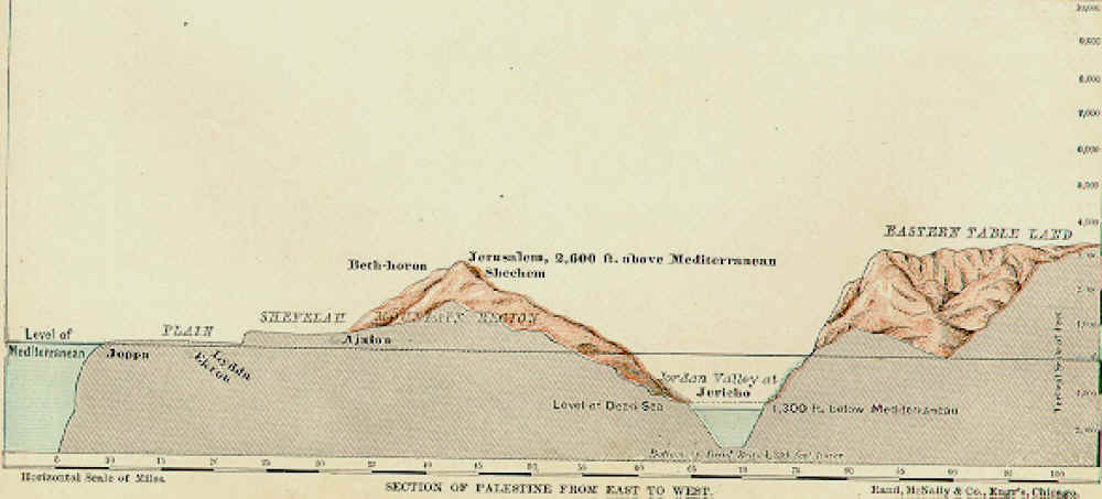
When Abraham and Lot looked out over the Valley of Siddim, what did they see? According to Genesis 13, “Lot looked around and saw that the whole plain of the Jordan toward Zoar was watered, like the Garden of the Lord, like the land of Egypt.” (Genesis 13:10, NIV) The biblical evidence indicates that in the time of Abraham there was a valley with a river that provided irrigation for the plain around Siddim, or the salt sea. Like the Nile River in Egypt, the Jordan River had created a lush oasis in a forbidding desert.
This description in Genesis, written about an event that occurred over 4000 years ago, is not far from what we observe today.
Other depictions of the Dead Sea in the Bible and other texts provide a picture of a deep rift valley familiar to us: natural freshwater springs, a lake of salt, a mountain of salt with caves, tar oozing out of the ground, and natural pits in the valley floor.
So the first time we hear about the Dead Sea in the Bible, it had already established its modern-day characteristics. But how did it come to be this way? In this post, we will look at some of the specific characteristics of the Jordan Valley, as I will usually refer to it, and the standard geological model of their origins.

Part I: A Geo-Biblical Exploration
Part II: The Lowest Place on Earth
Part III: A Land Literally Ripped Apart
The Lowest Surface on Earth
The most pressing question about the Dead Sea’s origins is it great depth. How did the Dead Sea form more than 1400 feet below sea level? After all, the Mediterranean Sea is only 60 miles from the Dead Sea valley. The Mediterranean is also a deep basin, but it is filled with water. The origins of the Red Sea, Mediterranean Sea and other water bodies in the world are superbly explained by one of the most elegant scientific theories of the past century: plate tectonics. Plate tectonic theory posits that the earth’s crust is composed of many large and small plates that are in constant motion. This theory provides an explanation for the majority of the earthquake and volcanic activity on earth today and in the past. It also provides a well-tested theory that accounts for the observations made of the Jordan Valley and the Dead Sea itself.
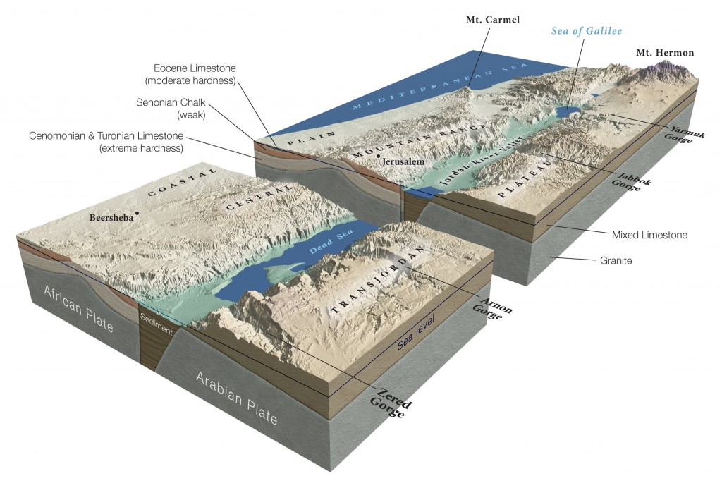
The Dead Sea sits in what is referred to as the Jordan Valley rift system. The west side of the valley is part of the African plate and the east side is part of the Arabian plate. These two plates are sliding past each other, and in a few places they are also pulling apart from one another. The result of this sliding and pulling is a rift valley. As the plates have pulled apart, the area between the plates has subsided resulting in a sediment filled crack well below sea surface.

This part of the Middle East is literally being ripped and torn apart geologically. This process occurs much slower than the political upheaval that we see in the region, but it nonetheless has sculpted this region over millennia and has produced many of the geographical characteristics that we associate with the Promised Land, as recorded in the Bible, such as the Judean Mountains, Dead Sea, Jordan River, and the Wilderness of Judea.
Slipping, Lifting, Falling
This rift caused by what is known as the Dead Sea transform fault is more than just two continents sliding past each other. That motion is causing some land to rise, some to fall, some to move north some south, and some to bend slowly over time. For example, the Jordan plateau east of the rift valley is both rising slowly over time and moving toward the north. Satellite-based measurements made in the past decade have observed these phenomena directly providing very precise rates of motion. At the Dead Sea, the mountains to the east are moving to the north at about 4.6 mm per year (less than 1/4 of an inch) and the plateau is rising at a rate slightly slower than that (1). These are very slow rates compared to most other continental plates. For example, the San Andreas Fault in California is moving at rates between 1.3 to 1.5 inches per year, and Hawaii is moving away from North America at approximately 3.5 inches per year.

Despite its tortoise-like rate of movement, the Arabian plate, over long periods of time, has been offset up to 60 miles from the point when the fault was first established. It is not surprising, then, to find that the rock layers on the canyon walls on each side of the Dead Sea don’t match up. The layers of rock on the west side of the valley find their match on the east side about 60 miles to the north, just as plate tectonic theory would predict.
Global positioning satellites have measured how fast this motion is happening right now, but how about movement in the past? Radiometric methods have been used to establish the position of plates in the past. That in turn can be used to estimate average rates of motion of those plates over millions of years . For example, if a plate is estimated to have moved 10 miles in 1 million years then we can calculate that the plate has moved an average of 0.63 inches per year over the million years to attain its present position. When these radiometric methods of estimating average plate motions over millions of years are performed, they produce similar estimates of plate motion as do modern GPS measurements. This is powerful data that suggests that these plates have been moving at the present day rates of motion for very long periods of time. This method produces similar estimates of plate motion as do modern GPS measurements, strongly suggesting that the plates have been moving at a similar rate for very long periods of time (1).

That plate motion has been felt and recorded over the past 4000 years. Many destructive earthquakes are reported in the Bible, and we will see the scars of those earthquakes in the sediment record of the Dead Sea later in this series.
How much has the Arabian plate moved north over the past 4000 years of recorded history? Based on the estimates of movement over the past million years and the actual measurements of movement over the past decade we can calculate that 4000 years ago that the Arabian plate has shifted to the north about 60 feet.
Formation of the Jordan Valley
This plate motions I have described so far don’t fully account for the features of the Jordan Valley.

Map by Patricia J. Wynne Figure and legend from: http://www.naturalhistorymag.com/htmlsite/1003/1003_feature.html
If the two plates only slid past each other, there would only be a scar through the Middle East that looks like the San Andreas Fault in California. But “fault-block rifting” is also occurring, resulting in an ever-widening fissure. This fissure eventually became a valley, as sediment slowly filled the crack. That valley is now about five miles wide, and as it widens, the sediments in the basin continue to fall further into the wedge. That subsidence of the valley contents continues to outpace the input of sediments which contributes to the lowering of the Jordan Valley and Dead Sea.
The Jordan Valley itself is sinking.
The fall of the valley floor isn’t constant but rather takes place in sudden bursts during large earthquakes, but averaged out over time, it is only falling around an inch a year (3). At the same time, the Jordan Plateau to the east is slowly being pushed causing the mountains to the east of the Jordan Valley to increase in height over time even in the face of erosion of their peaks.

A Gradual Evolution of the Jordan Valley
The picture that develops from hundreds of studies of the plate tectonics of the region paints a picture of a rift in the earth that has been slowly evolving over time. Tectonic movements inferred over millions of years and measurements made of movements in the present both confirm that the Jordan Valley has been millions of years in the making.
This plate tectonic geological explanation for the origins of the Dead Sea doesn’t leave much room for rapid and recent origin of the Dead Sea and Jordan Valley that young earth creationists espouse. Before we ask how biblical literalists attempt to squeeze the evolution of the Dead Sea into 4500 years we need to explore one other question.
Has the Jordan Valley ever been filled with water?

Whatever your beliefs about the age of the earth you might expect that it has and you would be right. But what do we know about this past lake named Lisan? When did it exist, what did it leave behind and how did it form?
We will explore these questions in Part IV before turning our attention to how these observations have been interpreted with respect to the historical information we can glean from the Bible.
Cited References:
1. ArRajehi et al. 2014. Geodetic constraints on present-day motion of the Arabian Plate: Implications for Red Sea and Gulf of Aden rifting. Tectonics. Volume 29, Issue 3, June 2010

2. Abraham Hofstetter, Catherine Dorbath, and Louis Dorbath. 2014. Instrumental Data on the Seismic Activity Along the Dead Sea Transform. In. Z. Garfunkel et al. (eds.), Dead Sea Transform Fault System: Reviews, 263 Modern Approaches in Solid Earth Sciences 6, DOI 10.1007/978-94-017-8872-4_9,© Springer Science+Business Media Dordrecht 2014
3. Al-Zoubi, A., & ten Brink, U. (2002). Lower crustal flow and the role of shear in basin subsidence: an example from the Dead Sea basin. Earth and Planetary Science Letters, 199(1), 67-79.
General References:
Ten Brink, U. S., Ben‐Avraham, Z., Bell, R. E., Hassouneh, M., Coleman, D. F., Andreasen, G., … & Coakley, B. (1993). Structure of the Dead Sea pull‐apart basin from gravity analyses. Journal of Geophysical Research: Solid Earth (1978–2012), 98(B12), 21877-21894.
Girdler, R. W. (1990). The Dead Sea transform fault system. Tectonophysics,180(1), 1-13.