As a biologist who frequently ventures into geological discussions, I’ve found that some of the most compelling evidence for Earth’s ancient age comes not from complex laboratory analyses or sophisticated dating techniques, but from features we can observe with our own eyes. The Goosenecks of the San Juan River in southern Utah represent one such example – a spectacular series of entrenched meanders that tell a story of time that simply cannot be compressed into a few thousand years. I’ve taken my family to this remarkable site and in this video, I document why these geological formations present such a significant challenge to young Earth flood geology models.
Deep Time Written in Rock
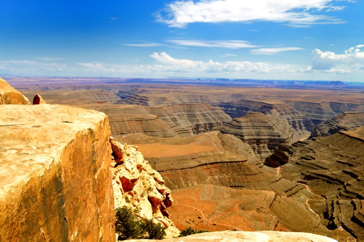
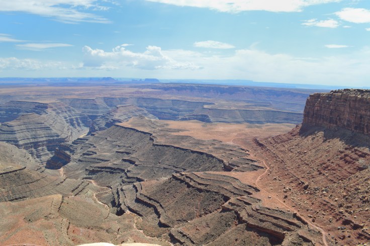
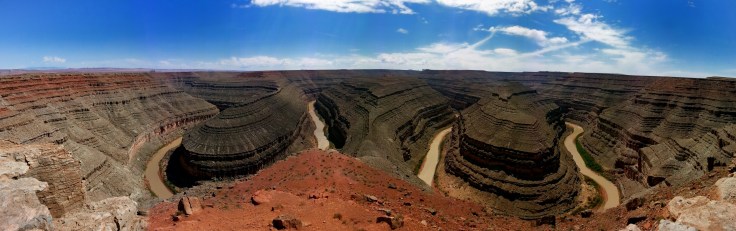
Standing at the overlook of the Goosenecks, visitors are confronted with an astounding sight: a river that travels six kilometers to advance just 1.5 kilometers as the crow flies. The river has carved through a thousand feet of rock, creating sharp bends that appear to almost connect back with themselves. These aren’t just any bends – they’re entrenched meanders, and their very existence tells us something profound about how they formed. The process requires two key ingredients: time and gradual uplift of the surrounding landscape.
Young Earth creationists often suggest—out of necessity it seems—these formations could have been carved rapidly during the recession of Noah’s flood or in its immediate aftermath. They propose that an enormous lake, covering an area larger than some states, suddenly burst through its natural dam and carved these canyons in a matter of days or weeks. However, the very existence of such tight meanders defies rapid formation, as catastrophic water flow would cut straight through rather than following such a twisted path. Specific features of this particular entrenched meander also speaks to the fact it was not produced rapidly which are discussed in the video above.
The Mount St. Helens False Equivalency
Proponents of flood geology often point to the canyons formed after the Mount St. Helens eruption as evidence that deep canyons can form rapidly. While it’s true that the Mount St. Helens event created impressive erosional features quickly, the comparison falls apart under scrutiny. The Mount St. Helens canyons were carved through soft volcanic ash, not solid rock, and they lack the meandering patterns we see in places like the Goosenecks, Horseshoe Bend or even the Grand Canyon itself. The Mt St Helens canyons run nearly straight and are steeply sloped – exactly what we’d expect from rapid erosion – rather than displaying the complex meandering patterns that require slow formation over time.
Why The Evidence Matters
These geological features aren’t just aesthetically impressive – they’re natural laboratories that help us understand Earth’s processes and history. The pattern of erosion we observe at the Goosenecks aligns perfectly with our understanding of slow uplift of the region combined with steady river flow over hundreds of thousands of years. Recent studies of gravel deposits at different heights along the canyon walls confirm this timeline, showing progressively older gravel deposits as you move up the canyon sides – exactly what we’d expect from gradual formation but impossible to explain in a rapid-formation scenario.
The Goosenecks of the San Juan River stand as a testament to deep time, challenging us to expand our perspective beyond human timescales. While young Earth creationists can propose hypothetical scenarios for rapid formation, these proposals consistently fail to account for the actual features we observe. As a scientist and educator, I find these formations particularly valuable because they provide tangible, observable evidence that anyone can understand – no sophisticated equipment or complex theories required. We don’t need radiometric dating to tell us how old this place is. Sometimes the most powerful evidence is simply what we can see with our own eyes.