When Abraham and Lot looked out over the Valley of Siddim, what did they see? According to Genesis 13, “Lot looked around and saw that the whole plain of the Jordan toward Zoar was watered, like the Garden of the Lord, like the land of Egypt.” (Genesis 13:10, NIV) The biblical evidence indicates that in the time of Abraham there was a valley with a river that provided irrigation for the plain around Siddim, or the salt sea. Like the Nile River in Egypt, the Jordan River had created a lush oasis in a forbidding desert.
This description from Genesis, written about an event that occurred over 4000 years ago, is not far from what we observe today. Other depictions of the Dead Sea in the Bible and other texts provide a picture of a deep rift valley familiar to us: natural freshwater springs, a lake of salt, a mountain of salt with caves, tar oozing out of the ground, and natural pits in the valley floor.
So, the first time we hear about the Dead Sea in the Bible, it had already established its modern-day characteristics. But how did it come to be this way?
We have explored the recent history of the Dead Sea and what its near future looks like. But all geological features have an origins story. They haven’t always existed. The Dead Sea was surely not always as it appears today or even as it appeared 4000 years ago.
The Dead Sea Transform: A Continental Divide
Have you ever wondered what it would feel like to stand on the edge of two continents? To place one foot in Africa and the other in Asia? Well, if you’ve visited the Dead Sea region, you’ve done just that without even realizing it! This part of the Middle East is literally being ripped and torn apart geologically. This process occurs much slower than the political upheaval that we see in the region, but it nonetheless has sculpted this region over millennia and has produced many of the geographical characteristics that we associate with the Promised Land, as recorded in the Bible, such as the Judean Mountains, Dead Sea, Jordan River, and the Wilderness of Judea.
The Dead Sea Rift, also known as the Dead Sea Transform fault, is a remarkable geological feature that has shaped the landscape of the Levant. But what exactly is a rift, and how did this one form? Let’s break it down.
The Dead Sea doesn’t just sit in a simple valley. It occupies a deep gash in the Earth’s crust known as the Dead Sea Transform (DST). This transform fault system is a plate boundary, separating the Arabian Plate to the east from the African Plate (or more specifically, its Sinai sub-plate) to the west. It’s part of a larger fault system that extends about 1000 km from the Red Sea in the south to Turkey in the north.
But what exactly is a transform fault? Imagine two massive pieces of the Earth’s crust sliding past each other, like two ships passing in the night. Don’t let the jargon intimidate you – it simply means that if you were to stand on one side of the fault and look across, you’d see the other side moving to your left. Well, you might not see it during your lifetime unless you experienced a significant earthquake which has happened in this region. The overall pace of the movement of these plates is excruciatingly slow – we’re talking millimeters per year. This motion has been ongoing for millions of years, gradually tearing the landscape apart and creating the distinctive rift valley we see today.
The Birth of a Rift
Geologists have gathered evidence leading them to conclude that the story of the Dead Sea Transform begins around 20-25 million years ago, during the early Miocene epoch. At this time, the Arabian Plate began to separate from the African Plate, initiating the opening of the Red Sea and the Gulf of Aden. As these plates moved apart, a new plate boundary formed along what we now call the Dead Sea Transform.
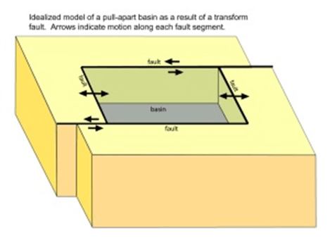
This tectonic divorce wasn’t a clean break, though. The relative motion between the plates is primarily horizontal (left-lateral strike-slip), but there’s also a component of extension, especially in certain areas. This combination of strike-slip and extensional motion has resulted in an opening up of a large crack between the plates creating a series of deep, sediment-filled basins along the transform, including the Dead Sea basin itself.
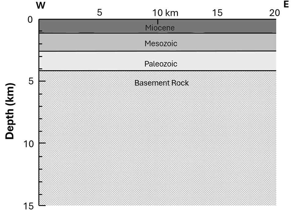
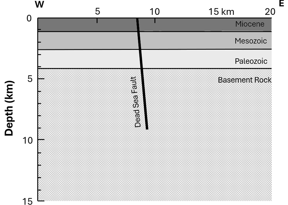
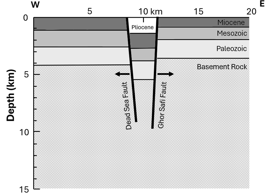
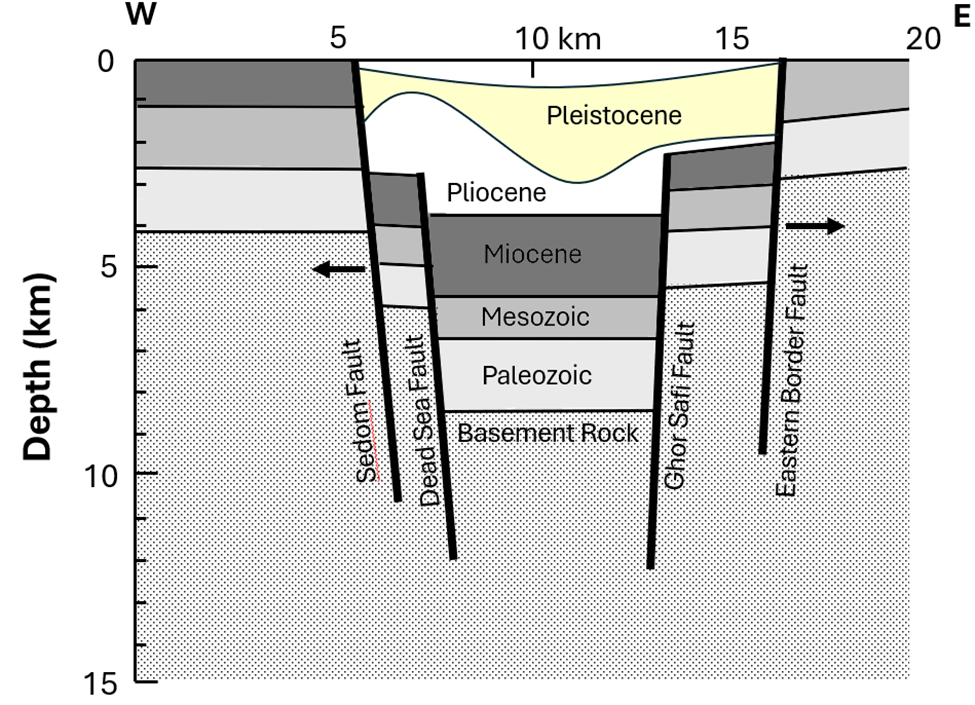
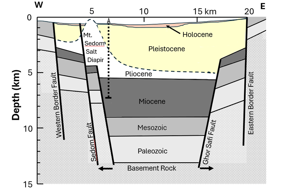
Below is series of simply cross sections of the geology from the Mediterranean coast on the left the areas east of the Dead Sea basin on the right.
A plate-tectonic tracker in your pocket?
But you might be asking yourself, how do we know all this? How can we measure the motion of entire continents? This is where modern technology comes to our aid. GPS satellites, the same ones that help you navigate to your favorite coffee shop, are being used to track the minute movements of the Earth’s crust with incredible precision.
Recent GPS studies have provided us with the most accurate measurements yet of plate motion in this region. According to ArRajehi et al. (2010), the Arabian Plate is moving northward relative to the African Plate at a rate of about 4-5 mm per year. That might not sound like much, but over millions of years, it adds up to hundreds of kilometers of displacement!
These GPS measurements align remarkably well with geological estimates of long-term motion, suggesting that the rates we observe today have been relatively constant for at least the past 11 million years. This consistency allows us to extrapolate backwards in time with some confidence, helping us reconstruct the tectonic history of the region.
A skeptic might naturally respond to this extrapolation of current-day GPS measurements, how do you know what happened in the past? Where you there to see those movements millions of years ago? How do scientists know what happened millions of years ago?
Those are good questions! While GPS measurements give us a precise picture of current plate motions, geologists have other tools to peer into the past. One of the most powerful is paleomagnetism. This technique allows us to track plate movements over millions of years, providing a crucial link between present-day observations and the long-term geological record.
Paleomagnetism works because the Earth’s magnetic field leaves a signature in certain minerals as rocks form, acting like a tiny compass frozen in time. When volcanic rocks cool or sediments settle on the ocean floor, magnetic minerals within them align with Earth’s magnetic field. This alignment is preserved as the rocks solidify, creating a record of the magnetic field’s orientation at that moment in geological time (Behar et al., 2019).
What makes this particularly useful for studying plate motions is that Earth’s magnetic field periodically reverses polarity – north becomes south and vice versa. These reversals are recorded in rocks worldwide, creating a distinctive pattern of magnetic “stripes” on the ocean floor. By mapping these stripes and determining their ages, scientists can calculate how fast the seafloor has spread over time. For example, in the Red Sea, which is connected to the Dead Sea rift system, paleomagnetic studies have revealed spreading rates of about 10 mm/year over the past five million years (Eppelbaum et al. 2023; Muluneh et al. 2013 ). This aligns remarkably well with the GPS-measured rates we see today, providing strong evidence for the consistency of plate motions over long periods of time.
In the specific context of the Dead Sea rift, paleomagnetic studies have been crucial in reconstructing its complex history. Researchers have examined the magnetic properties of both volcanic rocks and sediments along the rift, allowing them to track how different sections have moved relative to each other over time. For instance, a study by Ron et al. (1984) used paleomagnetism to show that parts of the Galilee region have rotated counterclockwise relative to the African plate over the past five million years, providing insights into the intricate movements that have shaped this region. These paleomagnetic results, combined with other geological evidence and modern GPS data, give us a comprehensive picture of how the Dead Sea rift has evolved over millions of years.
A 3D View of the Rift
But the story of the Dead Sea Rift isn’t just about horizontal motion. The rift has also experienced significant vertical movement. As the plates slide past each other, they also pull apart slightly, causing the crust to thin and sink. As it sinks erosion of sediments from the land around the rift supply sediments which fill the valley even as the valley flow continues to sink as the crack widens. However, the pace of filling the crack has not kept up with the sinking of the material into the crack. This is why the Dead Sea is so deep – it’s literally a depression in the Earth’s surface caused by this tectonic activity.
Thanks to advances in geophysical imaging techniques, we now have an unprecedented view of the subsurface structure of the Dead Sea basin. Segev et al. (2018) used a combination of gravity, magnetic, and seismic data to create detailed 3D models of the basin. These models reveal a complex structure, with the basin reaching depths of up to 10 km in some places!
The basin isn’t just a simple hole in the ground, though. It’s filled with layers upon layers of sediments, including thick deposits of salt. This salt plays a crucial role in the ongoing evolution of the basin through a process known as salt tectonics. As the weight of overlying sediments increases, the salt can flow and deform, creating complex structures and influencing the overall shape of the basin (Weinberger et al., 2006).
The Jordan Valley itself is sinking
It is not just the land under the Dead Sea that is sinking, the entire Jordan Valley is sinking. The fall of the valley floor isn’t constant but rather takes place in sudden bursts during large earthquakes, but averaged out over time, it is only falling around an inch a year (Al-Zoubi & ten Brink, U. 2002). This falling of the valley floor over hundreds of thousands of years has resulted in it being the lowest place on earth. At the same time, the Jordan Plateau to the east is slowly being pushed up causing the mountains to the east of the Jordan Valley to increase in height over time even in the face of erosion of their peaks.
figure here
Global Context: Not Just a Local Phenomenon
While the Dead Sea Transform is unique in many ways, it’s not the only rift system in the world. In fact, it shares many similarities with other continental rift zones, such as the East African Rift System. Both are characterized by long, narrow valleys, volcanic activity, and the formation of deep lakes.
These similarities allow geologists to draw insights from one system to better understand another. For example, studies of active rifting in East Africa can help us understand processes that may have occurred in the Dead Sea region millions of years ago.
Challenging Young Earth Views
Now, let’s address the elephant in the room. If you adhere to a young Earth creationist view, you might be feeling a bit skeptical right now. After all, we’re talking about processes that took place over millions of years, far longer than the proposed 6,000-year age of the Earth in young Earth models.
It’s important to understand that the evidence for these long-term processes isn’t just based on a single line of evidence. It comes from multiple, independent sources: GPS measurements, radiometric dating of rocks, paleomagnetic data, thermochronology, and more. Each of these methods points to the same conclusion – that the Earth is indeed very old, and that the Dead Sea Transform has been active for millions of years.
The geological evidence we’ve discussed – the 65 miles of offset along the fault, the thick layers of sediment in the basin, the magnetic signatures in the rocks – all point to processes occurring over millions of years. For those adhering to a young Earth view, this presents a significant challenge.
Some young Earth creationists have attempted to explain the formation of the Dead Sea Rift as a catastrophic event involving rapid movement of the continental plates during or shortly after Noah’s Flood. However, this explanation struggles to account for the observed evidence. The slow, steady motion we see today, confirmed by GPS measurements, is consistent with the gradual movement that formed the rift over millions of years. It’s difficult, No, impossible by any known mechanism, to reconcile this with a catastrophic formation in just a few thousand years.
Moreover, the idea of catastrophic plate tectonics occurring during a year-long global flood faces several physical impossibilities. The amount of heat that would be generated by plates moving at the speeds required to form all of Earth’s current geography in such a short time would be enough to boil the oceans and melt the Earth’s crust.
The “Heat Problem”
The “heat problem” bears some further explanation since it has become a focal point of discussion between ancient and young-earth advocates. Both sides recognize this is a significant challenge for young-earth creationist (YEC) models that attempt to compress the Earth’s geological history into a timeframe of about 6,000 years. This issue arises from the enormous amount of heat that would be generated if all of Earth’s geological processes, particularly plate tectonics and radioactive decay, occurred within such a short period.
In the conventional geological model, plate tectonic movements occur at rates of a few centimeters per year, allowing heat to dissipate gradually. However, if the same amount of movement were to occur within the YEC timeframe, plates would need to move at rates of meters per second. The friction from such rapid movement would generate enormous amounts of heat, potentially enough to melt the Earth’s crust and boil the oceans.
This problem has been apparent for more than 20 years when the first studies quantified this problem. For example, Dr. Baumgardner (2003), a creationist scientist, calculated that if plate tectonics operated at the speed required by a young-earth model, it would release enough heat to vaporize Earth’s oceans and melt a significant portion of the crust and mantle. Another way to think about it; the heat generated by accelerated plate tectonics in a young-earth scenario would be equivalent to the impact of a large asteroid every day for 4,500 years. Dr. Wiens (2002), a Christian astrophysicist and critique of creationism, pointed out that if all radioactive decay occurred within 6,000 years, the heat produced would be sufficient to vaporize all of Earth’s oceans and melt its crust and much of the mantle.
More recent critiques of the creationist “heat problem” have further solidified its status as a major challenge to young-earth models. In a comprehensive review, Worraker (2018) and Warraker and Ward (2018) examined various heat sources associated with Genesis Flood models, including accelerated nuclear decay, catastrophic plate tectonics, and extraterrestrial bombardment. He concluded that the total heat generated is “overwhelmingly large” and cannot be removed from the biosphere within a biblically-compatible timescale by known natural processes.
Popular science communicators have also addressed this issue. For instance, YouTube educator “Gutsick Gibbon” has produced multiple videos explaining the heat problem in accessible terms, demonstrating its continued relevance in creationism debates (Gutsick Gibbon, 2023, 2024). https://youtu.be/UIGB0g2eSFM and https://youtu.be/1zylJA0bly0 These discussions highlight that despite decades of awareness, young-earth creationists have yet to provide a scientifically plausible solution to the heat problem without resorting to supernatural interventions or speculative physics.
Most creationist researchers do acknowledge the severity of the heat problem. For example, the RATE (Radioisotopes and the Age of The Earth) project recognized that their proposed accelerated radioactive decay during the Flood would generate enough heat to “vaporize all the waters of the oceans and melt portions of the earth’s crust”. Creationist responses to the heat problem generally fall into three categories:
- Appealing to unknown or miraculous cooling mechanisms. Some suggest God supernaturally removed the excess heat or that unknown physical processes allowed for rapid cooling.
- Proposing speculative natural cooling mechanisms. For instance, Russell Humphreys (1994) suggested a cosmic expansion cooling effect, though this has been criticized on multiple grounds.
- Ongoing research attempts. Some creationists continue to investigate potential solutions, though no widely accepted natural mechanism has been found.
The scientific community, including myself, largely views such explanations as violating the principle of parsimony and lacking predictive power. Moreover, the continued accumulation of evidence supporting conventional geological timescales and mechanisms has made it increasingly difficult for YEC proponents to reconcile their models with the observed data without resorting to increasingly complex and ad hoc explanations.
Conclusion
The Dead Sea Transform is a testament to the dynamic nature of our planet. It’s a place where we can literally see the effects of plate tectonics written in the landscape. From the deep rift valley to the salty waters of the Dead Sea itself, every feature tells a story of millions of years of geological processes.
As we’ve seen, the evidence for the long-term, gradual development of this region is overwhelming. It comes from multiple independent lines of evidence, all pointing to the same conclusion. While this may challenge some traditional interpretations of Scripture, I believe it also invites us to marvel at the grandeur and complexity of God’s creation.
Before we ask how biblical literalists attempt to squeeze the evolution of the Dead Sea basin into just 4500 years we need to explore one other question.
Has the Jordan Valley ever been filled with water?
In our next installment, we’ll travel back in time to explore Lake Lisan, the Pleistocene precursor to the Dead Sea. We’ll see how this ancient lake provides crucial evidence for past climate changes and how its history poses significant challenges to flood geology models.
References:
Al-Zoubi, A., & ten Brink, U. (2002). Lower crustal flow and the role of shear in basin subsidence: an example from the Dead Sea basin. Earth and Planetary Science Letters, 199(1), 67-79.
ArRajehi, A., McClusky, S., Reilinger, R., Daoud, M., Alchalbi, A., Ergintav, S., … & Kogan, L. (2010). Geodetic constraints on present-day motion of the Arabian Plate: Implications for Red Sea and Gulf of Aden rifting. Tectonics, 29(3).
Baumgardner, J. R. (2003). Catastrophic plate tectonics: the physics behind the Genesis Flood. In Proceedings of the International Conference on Creationism (Vol. 5, No. 1, p. 13)
Behar N, Shaar R, Tauxe L, Asefaw H, Ebert Y, Heimann A, Koppers AAP, Ron H. Paleomagnetism and paleosecular variations from the Plio-Pleistocene Golan Heights volcanic plateau, Israel. Geochemistry, Geophysics, Geosystems. 2019.
Eppelbaum, L. V., Katz, Y. I., & Ben-Avraham, Z. (2023). Geodynamic Aspects of Magnetic Data Analysis and Tectonic–Paleomagnetic Mapping in the Easternmost Mediterranean: A Review. Applied Sciences, 13(18), 10541.
Humphreys, D.R. (1994). Starlight and time: Solving the puzzle of distant starlight in a young universe. Master Books.
Muluneh, A. A., Kidane, T., Rowland, J., & Bachtadse, V. (2013). Counterclockwise block rotation linked to southward propagation and overlap of sub-aerial Red Sea Rift segments, Afar Depression: Insight from paleomagnetism. Tectonophysics, 593, 111-120.
Ron, H., Freund, R., Garfunkel, Z., & Nur, A. (1984). Block rotation by strike‐slip faulting: Structural and paleomagnetic evidence. Journal of Geophysical Research: Solid Earth, 89(B7), 6256-6270.
Segev, A., Rybakov, M., Lyakhovsky, V., Hofstetter, A., Tibor, G., Goldshmidt, V., & Ben-Avraham, Z. (2018). The 1D structure of the lithosphere in the northern Arabian plate along the Dead Sea Transform. Tectonophysics, 747, 1-15.
Ten Brink, U. S., Ben‐Avraham, Z., Bell, R. E., Hassouneh, M., Coleman, D. F., Andreasen, G., … & Coakley, B. (1993). Structure of the Dead Sea pull‐apart basin from gravity analyses. Journal of Geophysical Research: Solid Earth (1978–2012), 98(B12), 21877-21894.
Weinberger, R., Lyakhovsky, V., Baer, G., & Begin, Z. B. (2006). Mechanical modeling and InSAR measurements of Mount Sedom uplift, Dead Sea basin: Implications for effective viscosity of rock salt. Geochemistry, Geophysics, Geosystems, 7(5).
Wiens, R.C. (2002). Radiometric dating: A Christian perspective. American Scientific Affiliation.
Worraker, W. (2018). Heat Problems Associated with Genesis Flood Models—Part 1: Introduction and Thermal Boundary Conditions. Answers Research Journal, 11, 171-191.
Worraker, W. J., & Ward, R. (2018). Modeling of Flood and post-Flood ocean floor cooling. In Proceedings of the International Conference on Creationism (Vol. 8, No. 1, p. 15).
