Welcome back to our journey through the geological wonders of the Dead Sea region! In our previous installments, we’ve explored the formation of the Dead Sea itself, the ancient Lake Lisan, and the seismic history recorded in the sediments. Today, we turn our attention to one of the most striking features in this landscape: Mount Sodom, a mountain made almost entirely of salt.
This isn’t just any hill of salt, mind you. Mount Sodom is a geological marvel that rises 742 feet above the Dead Sea shoreline, stretches eight miles long and three miles wide. But more than its impressive size, this salt mountain holds clues to the deep history of the region – clues that present a serious challenge to the young-earth interpretations of Earth’s history.
The Basics of Mt. Sodom
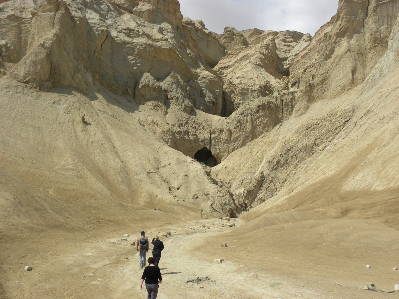
Rising out of the plain at the southwestern end of the Dead Sea, Mount Sodom is a billion-ton mountain of salt. Its stark white cliffs stand in sharp contrast to the surrounding desert landscape, a testament to the unique geological processes that shaped this region.
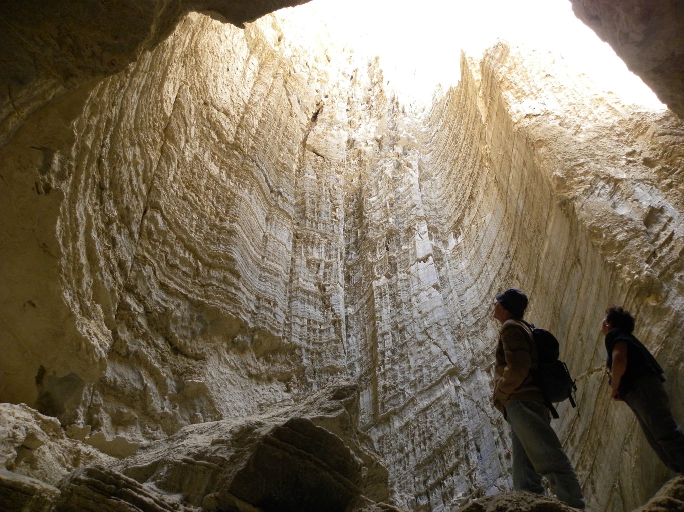
Composed almost entirely of halite (rock salt), Mount Sodom has been sculpted over time by rainfall and groundwater, creating numerous caverns within its salt dome. These caves have a rich history of human occupation, with some suggesting they may have sheltered biblical figures like Lot as he fled the destruction of Sodom and Gomorrah, or served as a hideout for David while evading King Saul.
The mountain’s very name evokes its biblical connections, though as we’ll see, its history stretches far beyond the timeline of human records.
The Geology of Mt. Sodom
To understand Mount Sodom, we need to learn more about salt tectonics, specifically a process known as salt diapirism. Don’t worry if these terms sound intimidating – we’ll break them down step by step.
Salt diapirism is a process where salt, buried under layers of denser rock, essentially bubbles up through these layers due to its relative buoyancy and ability to flow over long periods of time. It’s somewhat like what happens when you shake a lava lamp – the less dense material rises through the denser fluid. In geological terms, this process can create structures called salt domes or, in extreme cases like Mount Sodom, entire mountains of salt (Warren, 2016).
The story of Mount Sodom begins deep underground. Geological studies, including recent ground-penetrating radar surveys, have revealed that the roots of Mount Sodom lie in a thick layer of nearly pure halite buried under almost 10,000 feet of sediments and rock (Al-Zoubi and ten Brink, 2001). This salt layer is a remnant from a time when the Dead Sea rift had a periodic connection to the Mediterranean Sea, allowing seawater to flow in and evaporate, leaving behind massive salt deposits.
As more sediments piled on top of this salt layer over millions of years, the increasing pressure caused the salt to behave like a very slow-moving fluid. The salt, being less dense than the overlying rock, was gradually squeezed upward through weaknesses in the rock layers above. This process, occurring over hundreds of thousands of years, eventually pushed the salt to the surface, forming the mountain we see today.
What makes Mount Sodom particularly interesting is that this process is still ongoing. Recent satellite measurements have shown that Mount Sodom is still rising at a rate of about 3.5 mm per year (Yechieli et al., 2016). This might not sound like much, but in geological terms, it’s quite rapid.
To put Mount Sodom in context, it’s worth comparing it to other salt structures around the world. The Gulf Coast of the United States, parts of Iran, and northern Germany all have significant salt dome formations. However, Mount Sodom stands out for its size and the extent to which it has broken through to the surface. Most salt domes remain largely underground, detected only through geophysical surveys or encounters during oil drilling.
Latest Research on Mt. Sodom
Recent years have seen many advances in our understanding of Mount Sodom, thanks to new technologies and research methods. A 2018 study by Zucker et al. used high-resolution InSAR (Interferometric Synthetic Aperture Radar) data to map the ongoing deformation of Mount Sodom in unprecedented detail. They found that different parts of the mountain are rising at different rates, with some areas moving upward as fast as 5.5 mm per year. This differential movement is causing the mountain to tilt slightly, potentially increasing the risk of future collapse on its western side.
Advances in geophysical imaging techniques have also allowed scientists to peer deeper into Mount Sodom’s internal structure. A 2020 study by Ezersky et al. used a combination of seismic reflection data and gravimetry to create detailed 3D models of the salt body and its surrounding structures. Their work revealed complex patterns of faulting within and around the salt body, helping to explain its unusual shape and ongoing deformation.
The cave systems within Mount Sodom continue to yield new discoveries. Speleologists mapping the mountain’s extensive cave network have recently extended the known length of the Malham Cave to over 10 kilometers, making it the longest salt cave in the world (Frumkin et al., 2017). These caves not only provide insight into the mountain’s internal structure but also preserve evidence of past climate changes and human activity in the region.
Archaeological investigations in and around Mount Sodom have also continued to yield intriguing findings. A 2019 study by Langgut et al. analyzed pollen samples from cave deposits, providing new insights into the vegetation and climate history of the region over the past 10,000 years. Their work helps to contextualize the human history of the area, including the biblical narratives associated with Sodom and Gomorrah.
These recent studies have not only deepened our understanding of Mount Sodom itself but have also contributed to our broader knowledge of salt tectonics and the geological evolution of the Dead Sea region. As we’ll see next, this growing body of evidence poses significant challenges to young-earth interpretations of the region’s history.
Mt. Sodom and the Age of the Earth Debate
The geological evidence we’ve explored about Mount Sodom raises many questions when compared to the claims of young-earth creationism. Let’s compare this timeline with what the geological evidence from Mount Sodom suggests:
| Event | YEC Timeline | Geological Evidence |
| Formation of salt deposits | During Flood (~4,500 years ago) | ~3-15 million years ago |
| Burial of salt layer | Immediately post-Flood | Over millions of years |
| Start of salt dome formation | Post-Flood (<4,500 years ago) | ~2-3 million years ago |
| Cave formation | Post-Flood (<4,500 years ago) | Over hundreds of thousands of years |
| Human habitation | ~4,000 years ago | Intermittent over past 50,000 years |
The discrepancies here are stark. The geological evidence points to processes occurring over millions of years, while the YEC timeline must compress all of these events into just a few centuries at most.
Specific Challenges to Young Earth Interpretation
The formation of Mount Sodom poses several significant problems for the young-earth interpretation:
- Salt Accumulation: The sheer volume of salt in Mount Sodom and the underlying deposits would require an implausible rate of evaporation in a post-Flood scenario. The amount of salt present is more consistent with repeated cycles of seawater inflow and evaporation over millions of years (Torfstein et al., 2009).
- Uplift Time: Given the current measured uplift rate of 3.5 mm/year, it would take over 60,000 years for Mount Sodom to reach its current height – and this assumes the rate has remained constant, which is unlikely. The YEC timeline simply doesn’t allow enough time for this process.
- Cave Formation: The extensive cave systems in Mount Sodom, formed by dissolution of salt, require significant time to develop. The presence of speleothems (cave formations) in some of these caves further extends the required timeline (Frumkin et al., 2011).
- Erosion Patterns: The current form of Mount Sodom, with its steep cliffs and pillars, is the result of long-term erosion in an arid climate. A recent formation in a post-Flood world would not have had time to develop these features.
- Sedimentary Layers: The alternating layers of salt, gypsum, and clastic sediments in the Dead Sea basin, which Mount Sodom has pierced through, represent repeated cycles of climatic change. These cycles can’t be explained in a young-earth timeframe.
Conclusion
As research continues, we can expect to learn even more from this remarkable feature. Future studies may reveal new details about its internal structure, its rate of uplift, or the environmental conditions that have shaped it over time. Each new discovery adds another piece to the puzzle of Earth’s history, enriching our understanding of this unique region.
Mount Sodom stands as a testament to the power of geological processes acting over vast spans of time. Its very existence challenges us to think beyond the confines of human timescales and consider the deep history of our planet.
References:
Al-Zoubi, A., & ten Brink, U. S. (2001). Salt diapirs in the Dead Sea basin and their relationship to Quaternary extensional tectonics. Marine and Petroleum Geology, 18(7), 779-797.
Answers in Genesis. (2021). “Noah’s Flood and the Dead Sea Sediments.” Accessed online September 23, 2024.
Ezersky, M., Keydar, S., Al-Zoubi, A., & Eppelbaum, L. (2020). Geometry of the Dead Sea salt diapir flanks from 3D modeling of seismic reflection and gravity data. Tectonophysics, 779, 228376.
Frumkin, A., Ford, D. C., & Schwarcz, H. P. (2011). Continental oxygen isotopic record of the last 170,000 years in Jerusalem. Quaternary Research, 51(3), 317-327.
Frumkin, A., Langford, B., Lisker, S., & Amrani, A. (2017). Hypogenic karst at the Arabian platform margins: implications for far-field groundwater systems. Geological Society, London, Special Publications, 466(1), 217-241.
Langgut, D., Yannai, E., Taxel, I., Agnon, A., & Marco, S. (2019). Resolving a historical earthquake date at Tel Yavneh (central Israel) using pollen seasonality. Palynology, 43(1), 53-59.
Torfstein, A., Gavrieli, I., Katz, A., Kolodny, Y., & Stein, M. (2009). Gypsum as a monitor of the paleo-limnological-hydrological conditions in Lake Lisan and the Dead Sea. Geochimica et Cosmochimica Acta, 73(14), 4452-4468.
Warren, J. K. (2016). Evaporites: A geological compendium. Springer.
Yechieli, Y., Abelson, M., Bein, A., Crouvi, O., & Shtivelman, V. (2016). Sinkhole “predictability”: Assessment of collapse risk for various areas on the Dead Sea shores. Geological Society of America Today, 26(3), 4-10.
Zucker, E., Frumkin, A., Agnon, A., & Weinberger, R. (2018). Internal deformation and uplift-rate of salt walls detected by a displaced dissolution surface, Dead Sea basin. Journal of Structural Geology, 116, 284-297.

The height and its relationship to time scales reminds me of an old claim that you might be able to illuminate.
The claim was that, even if you had water covering the whole earth to the height of mountain tops, you would not have enough water in which to suspend enough sediment to account for the portion of the geologic column that YECs claim was deposited by the flood.
Have you seen any such computations?
LikeLike