Just how fast are some rocks on Mars eroding? A few months ago I asked a Martian rock that question (see: My Interview with a Martian: A Story of Origins) and I was not given a very satisfying answer. Well, that rock can be excused for being a bit confused about time given how boring it may be sitting on the surface so long with so little to do. But now we have sent a little rover called Curiosity to Mars to do some further investigations for us. That rover has some sophisticated analytical equipment on board. One of them can take drilled rock dust, heat it up until it melts and the smell the molecules that emanate from the melting crystals. What we learned this week is that some of the molecules that this instrument can measure are the kind that can be used to calculate radiometric ages. The precision of this instrument is not like we have in labs here on Earth but nonetheless it’s an impressive achievement and gives us our first direct test of age of rocks and allows to even infer rates of erosion of rocks.
NASA / JPL / MSSS / Emily Lakdawalla
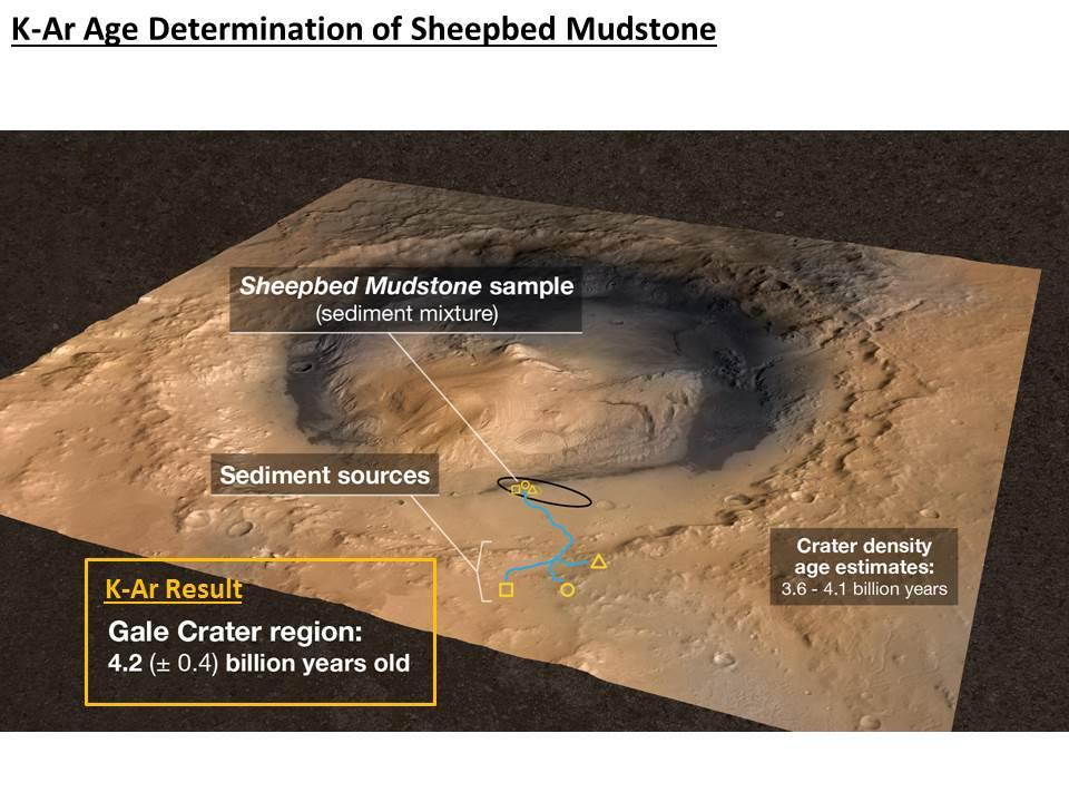
The first measurement reported in a paper entitled In Situ Radiometric and Exposure Age Dating of the Martian Surface published in Scienceprovided a K-Ar radiometric age for the rocks that make up the original rocks of the Gale Crater area. That measurement yielded an age of 4.2 billion years give or take a few hundred million years. This is on par with the oldest rocks on Earth and was the age predicted for this region of Mars based on relative methods of dating such as crater density counts.
NASA / JPL / MSSS
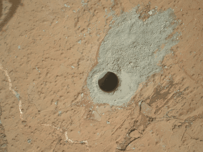
That date was expected but what was really interesting and relevant to the first question I posed is that they didn’t just measure the origin of the material in the rocks but they also produced a date of when a particular set of rocks came to be exposed at the surface. The whole area you see in the pictures above and below is thought to have been buried under many layers or rock which have been eroded over time to reveal the layers that we are seeing today.
Emily Lakdawalla reviews the significance of the dates. If you want to know everything that is happening in planetary science I highly recommend following her on Twitter (@elakdawalla). In her recent blog post “Curiosity results at AGU: Gale crater rocks are old, but have been exposed recently”Lakdawalla explains how the length of time a rock has been exposed at the surface can be calculated:
Mars lacks a significant magnetic field, so anything on its surface is exposed to bombardment by galactic cosmic rays. Galactic cosmic rays can produce specific isotopes of noble gases: argon-36, neon-21, and helium-3. These gases would not have been present in the rocks when they first formed, so if you know the rate at which the isotopes are produced on Mars, and if you measure their abundance in current rocks, you can estimate how long the rock has been exposed at, or near, the surface.

A form of this analysis can be done for rocks on Earth as well. It is called cosmogenic nuclide dating and it allows for rough estimates of the rates of erosion, or exposure times, in different locations (eg. how fast are rocks eroding in Utah vs deserts in other places in the world). So what can we learn about erosion on the surface of Mars from this form of analysis? Lakdawalla goes on to explain:
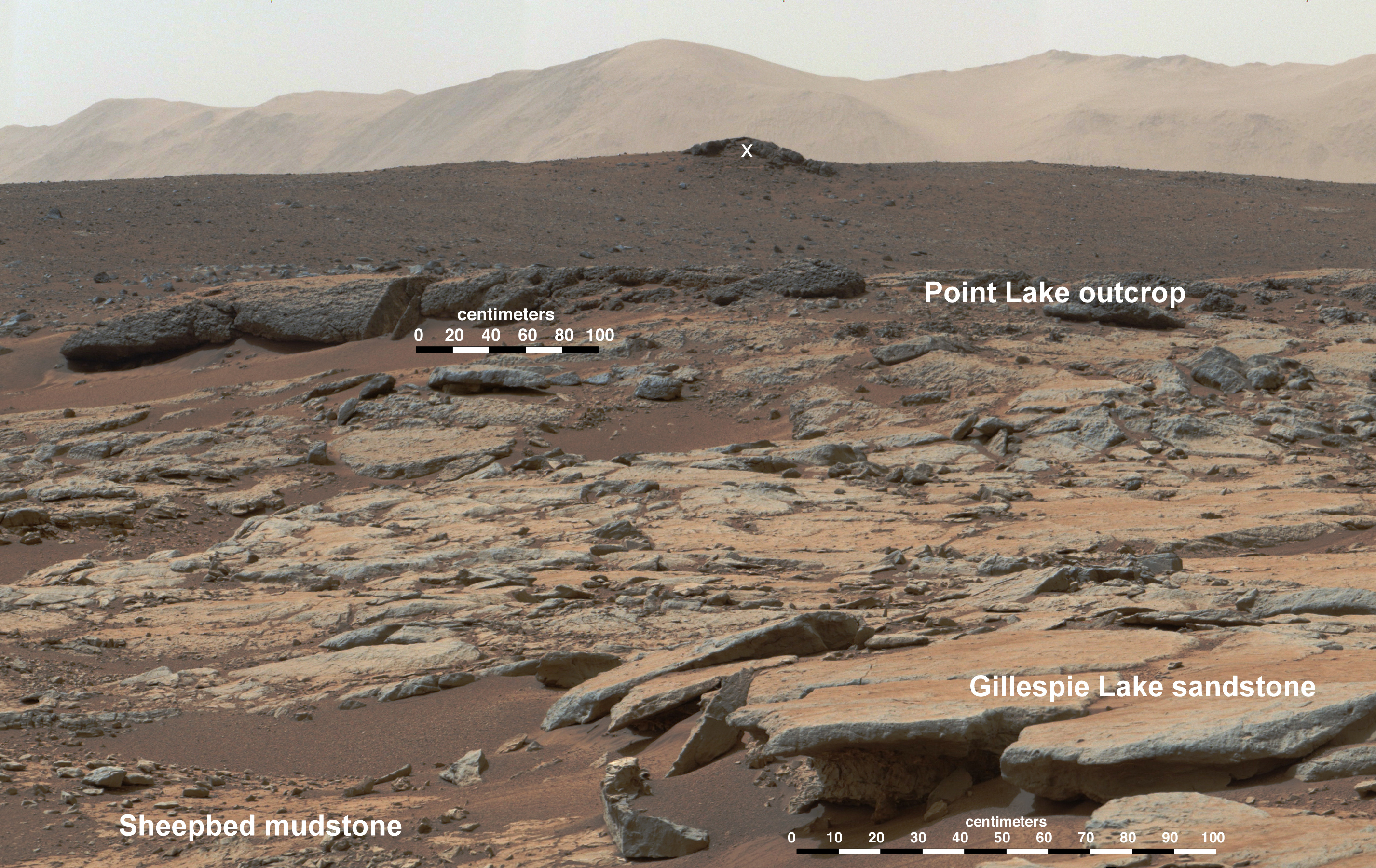
You can imagine how the relatively weak mudstones of the Sheepbed Unit are getting sandblasted away by wind scouring, and that’s undercutting the more resistant layers like Gillespie Lake. In other words, the Sheepbed rocks are being exposed by a process of scarp retreat. Assuming that this is a continuous and ongoing process, if you follow the direction of the wind, then, until you get to the scarp, that’ll take you to Sheepbed rocks that should be freshly exposed. You can estimate the rate of scarp retreat, and it’s about 1 meter per million years.
I think the operators of the Curiosity rover have come up with a pretty nifty way of estimating erosion. The 1 meter per million years is a very rough estimate so maybe it is only ½ meter or 2 meters per million years. Regardless, this suggests that erosion really is happening on Mars. You might think that 1 meter of rock erosion in 1 million years is a very very slow pace but remember the atmosphere is very thin on Mars and there is only wind and freeze/thaw cycles as the primary forces of change on the surface.

Back to our martian friend laying there on the surface (see picture to the right). In my interview (My Interview with a Martian: A Story of Origins) I asked this rock what would happen to him in the future? This was his reply:
Well, assuming you don’t poke me or shoot me with your little laser toy on your way by (referring to the Curiosity Rover obviously), I expect that I will continue to hang on for at least 10,000 more years but possibly several hundred thousand years or so after which I will probably have completely fallen apart into all those small stones that I was originally made of. Now those parts are much tougher than I was and wind and thermal tension won’t be able to tear them down so quickly so someday you will probably find a little pile of stones here spread out a bit as they are pushed slightly by the wind and sand over time. On the other hand, it is possible that another meteorite could hit near here and cover me with a blanket of rocks in which case those new friends would shield me from erosion and I might live for millions of years to come.
The prediction of 10,000 years or a bit longer seems about right given these new estimates of the rate of erosion. I had thought maybe he could last another million years but apparently erosion is occurring at a faster pace than I would have guessed. Still, this little rock is but a very small piece of the geological terrain in the area that includes many small meteor craters and many hundreds of meters of rock that have been eroded in the area before our little friend even came to find his way to his present location.
The Curiosity rover science team has now collected enough evidence to convince them the rover is now driving around on rock that was deposited originally as sediments in a large lake. But that lake has been dry for hundreds of millions of years if not billions of years. Since then massive amounts of rock have eroded and small new craters have been created and eroded and then covered with even more debris from other cratering events. All the while wind has been slowing eating away at the rock surfaces and moving material from one place to another. If we took a snapshot today and came back one million years from now it might look very similar but in many subtle ways the landscape is constantly changing. It a dynamic planet but it’s a slow motion dynamism that we are seeing.

Thanks for the post – I just got done showing my daughter your background pic. Ordinarily I am reticent to use the word “awesome”, preferring to reserve it for something tantamount to a major cosmic event or tectonic adjustment, but the simple existence of clearly sedimentary rocks on Mars, in the opinion of this humble observer, qualifies as awesome. And your commentary is also quite elucidating – I expect standard science’s view of the aging of planetary surfaces, while different in Martian conditions, will continue to be vindicated, to the chagrin of our YEC brothers and sisters.
LikeLike
Yes, I find the pictures from Mars really amazing. The surface is far more complex that I had imagined it to be. The next few months should bring the rover down into the valley at the foot of the large mountain. Check out this picture from today: http://www.unmannedspaceflight.com/index.php?act=attach&type=post&id=31629 In the valley is where a large lake is thought to have stood at one time though it boggles my mind how hundreds of feet of rock has been eroded out of this valley since that time. God has provided a Universe of incredible diversity and one that we will never run out of things to wonder at.
LikeLike