A meandering river on a wide river plain running through Egypt is the source of one of the best-known ancient civilizations. But the Nile Valley has a deep secret. A huge canyon lies buried underneath the Nile Valley attesting to an ancient history of events that took place long before the Egyptians came to inhabit the fertile valley floor.
How could a canyon on the scale of the Grand Canyon in Arizona come to be buried under the Nile Valley? This is the first question we must address in our series exploring the Lost Grand Canyon of Egypt. The answer to that question will allow us to further explore questions about the age of the Earth and Biblical chronology that we mentioned in our first part of this series (The Lost Grand Canyon of Egypt: Another Monument to an Ancient Earth).

A partial answer to the origin of the buried canyon can be found at the Dead Sea. The Dead Sea lies over 1200 feet below sea level and is fed by the Jordan River most of which runs well below sea level. How does the Dead Sea maintain its current depth well below sea level?
Evaporation!
At least as much water evaporates from the Dead Sea as enters the sea from the Jordan River and other smaller tributaries. In fact, over the past decade much more water has evaporated from the Dead Sea than has arrived through rivers or rainfall. This is especially true today because irrigation removes water from the Jordan. As a result, the Dead Sea surface has become progressively lower each year. As it shrinks salt precipitates out of the water falling to the lake floor. This process occurring over long periods of time has resulted in the thousands of feet of salt deposited below the Dead Sea and the Dead Sea valley.
For more about the Dead Sea I’ve written a series of articles about the Dead Sea:
The Origins of the Dead Sea: A Geo-biblical Exploration
Part II: Origins of the Dead Sea: The Lowest Place on Earth Goes Lower
Part III: Origin of the Dead Sea: The Levant, a Land Literally Torn Apart
Part IV: Origins of the Dead Sea: Lake Lisan – The Jordan Valley Under Water
Part V: Origins of the Dead Sea: All Dried Up – No Room for a Dry Dead Sea in the Young Earth Timeline
Part VI: Origins of the Dead Sea: Sodom, Gomorrah, and the Seismic History of the Dead Sea: Support for Biblical History – Yes! Support for a Young Earth – No!
Part VII: Origins of the Dead Sea: Mt. Sodom – A Huge Pile of Salt
How do our observations of the Dead Sea help us explain the origins of the Nile Valley canyon? Ask yourself, where does the Nile River end?
It ends at a large delta spreading out into the Mediterranean Sea which sits at the average world-wide sea level. Today’s Nile River cannot erode the sediments of the Nile Valley any lower than the waters of the Mediterranean Sea. But what if the Mediterranean Sea had been lower—much lower—in the past?
It is well-established that during the last Ice Age the surface of the world’s oceans were hundreds of feet lower than they are today. As a result, where rivers run into the ocean they experienced erosion down into the sediments or rock below them, creating canyons. When the oceans rose as the ice melted from the continents it flooded those canyons many of which can be found submerged offshore on continental shelves today. Those canyons have been filling with sediments since being flooded.
But the Nile Valley canyon is 6000 feet below sea level at Cairo and even deeper where it enters the Mediterranean Sea. No reduction in sea-levels due solely to Ice Ages could perform this feat.
That brings us to another geological observation. A 1950s studies of the Mediterranean basin revealed that there are massive salt deposits buried beneath sediments surrounding the Mediterranean Sea basin. Some of these deposits have been extensively mined reaching levels well below that of sea level? A natural question arose from this observation, where did these layers of salt come from?
In addition, cores and seismic surveys of the rock below the Mediterranean Sea, especially the deepest portions, reveal massive layers of salt in some cases thousands of feet thick! Yes, massive amounts of rock salt are found underneath the Mediterranean Sea.
These discoveries led to a the proposal, or hypothesis if you prefer (see references), that the entire Mediterranean Sea had dried up in the past. This time—or times—of great drying of the Sea has been named the Messinian Salinity Crisis.
A dried up Mediterranean Sea! That might sound ridiculous at first. How could an entire sea dry up leaving a pile of salt behind? However, you need only look to the Dead Sea to see a miniature example of this occurring today. As I said before, the Dead Sea is drying up despite a river running into it. As water evaporates from the Dead Sea it precipitates salts which fall to the bottom of the sea. Under the Dead Sea are thousands of feet of salts of various types that have precipitated from the lake over many eons. There is abundant evidence that the Dead Sea once was a lake that was much larger and was connected to the Sea of Galilee and even the Mediterranean Sea. After becoming disconnected with the Mediterranean Sea, it has been shrinking nearly continuously as evaporation has usually exceeded input of new water.

It appears the same thing happened to the Mediterranean Sea in the past. That sea is very deep and so if it evaporated all the way down to a few small lakes like the Dead Sea today, some of those, especially in the eastern basin would have been more than 10,000 feet below sea level.
This parched history of the Mediterranean Sea was discovered by many geologists interested in the Mediterranean Sea looking for oil and other natural resources. But do you see how this history of the Mediterranean Sea and Dead Sea might help us to explain the origins of the Nile Valley canyon?
When the Mediterranean Sea was gradually drying up the Nile River—usually given another name in the geological literature like the Eonile or Paleonile—would have begun to erode down into the rock below. As erosion continued, it would cause the newly formed canyon to continue to form further back from the mouth of the Nile River. As the sea level dropped the erosion would continue to eat further down into the rock underlying Egypt and Sudan. Think of Niagara Falls and how it keeps eating back into the rock over which it flows.
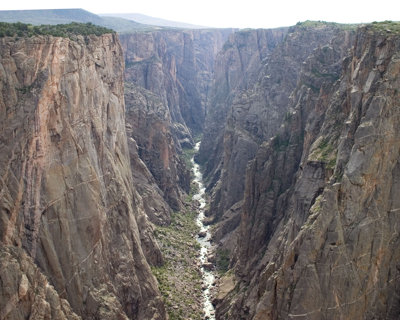
During its formation, the Nile canyon was probably a very steep cascade of spectacular water falls all the way from Sudan through Egypt. Since much of this erosion in the deepest portions of the canyon was into hard granites and we know the walls of the canyon were very steep I would imagine the deepest portion of the canyon would have looked something like the Black Canyon of the Gunnison in Colorado.
How did this ancient canyon become filled with sediment?
Today, this amazing canyon is obscured from our view since the entire canyon is filled with sediment. How did that happen?
The Messinian Salinity Crisis seems to have ended when tectonic forces caused the Straits of Gibraltar to form and water from the Atlantic Ocean could once again flow into the great basin. This catastrophic event filled the entire Mediterranean basin possibly within a couple of hundreds of years. With the Mediterranean Sea filled once again, those waters would have backed all the way up the Nile Valley canyon. Given the depth of the canyon that sea water would have pushed up through the canyon well into what is Sudan today. Had you been standing on the rim of the Nile Valley at Aswan at the time you would have been looking at a lake a mile wide and nearly 600 feet deep.
At that time the Nile River would have entered this long lake way down in southern Sudan. Over time, the sediments carried in the Nile River would have deposited enormous amounts of sediment into the canyon. Slowly but surely, the lake in the Nile Valley would have filled with sediments starting in southern Sudan and gradually filling up all the way up through Egypt until it reached the Mediterranean Sea where today it continues to push sediment out into the Mediterranean Sea forming a massive delta.

To visualize how this happens, imagine what would happen if you were to put a massive dam at the end of the Grand Canyon and the entire Grand Canyon were to fill with water. Over time sediments and organic matter brought to the lake by the river upstream would slowly accumulate in the canyon lake until the entire lake was filled. Eventually a large flat valley would form with a river running through it to the dam. This is what happened to create the Nile Valley we see today.
In the next post we will look at bit closer at when this happened, how long it would have taken for these processes to occur and some further evidence for the filling of the Nile Valley canyon. Then we will be ready to ask the most pertinent question: how can the existence of the Nile valley canyon be understood in the context of the biblical narrative?
References:
Ahmed, Ayman A., Adly Omer, Ahmed Yousef, and Shaymaa Rizk. “ASSESSMENT OF NITRATES AND THEIR HEALTH IMPACT IN QUATERNARY GROUNDWATER AQUIFER OF SOHAG GOVERNORATE, EGYPT.”
Duggen, Svend, Kaj Hoernle, Paul Van Den Bogaard, Lars Rüpke, and Jason Phipps Morgan. “Deep roots of the Messinian salinity crisis.” Nature 422, no. 6932 (2003): 602-606.
Fauquette, Séverine, Jean-Pierre Suc, Adele Bertini, Speranta-Maria Popescu, Sophie Warny, Naïma Bachiri Taoufiq, Maria-Jesus Perez Villa et al. “How much did climate force the Messinian salinity crisis? Quantified climatic conditions from pollen records in the Mediterranean region.”Palaeogeography, Palaeoclimatology, Palaeoecology 238, no. 1 (2006): 281-301.
Garcia-Castellanos, Daniel, Ferran Estrada, Ivone Jiménez-Munt, Christian Gorini, Manel Fernández, Jaume Vergés, and R. De Vicente. “Catastrophic flood of the Mediterranean after the Messinian salinity crisis.” Nature 462, no. 7274 (2009): 778-781.
Hsü, Kenneth J., Lucien Montadert, Daniel Bernoulli, Maria Bianca Cita, Albert Erickson, Robert E. Garrison, Robert B. Kidd, Frederic Mèlierés, Carla Müller, and Ramil Wright. “History of the Med Hsü, K.
Krijgsman, W., F. J. Hilgen, I. Raffi, F. J. Sierro, and D. S. Wilson. “Chronology, causes and progression of the Messinian salinity crisis.”Nature 400, no. 6745 (1999): 652-655.
Müller, Daniel W., and Paul A. Mueller. “Origin and age of the Mediterranean Messinian evaporites: implications from Sr isotopes.” Earth and Planetary Science Letters 107, no. 1 (1991): 1-12.
Nesteroff, W. D., and France VI. “21. MINERALOGY, PETROGRAPHY, DISTRIBUTION, AND ORIGIN OF THE MESSINIAN MEDITERRANEAN EVAPORITES.” Initial Reports of the Deep Sea Drilling Project: A Project Planned by and Carried Out with the Advice of the Joint Oceanographic Institutions for Deep Earth Sampling 13 (1973): 673.
Rouchy, Jean Marie, and Antonio Caruso. “The Messinian salinity crisis in the Mediterranean basin: a reassessment of the data and an integrated scenario.” Sedimentary Geology 188 (2006): 35-67.
Ryan J., W. B. F., and M. B. Cita. “Late Miocene desiccation of the Mediterranean.” Nature 242, no. 5395 (1973): 240-244.
Ryan, W. B. F., Decoding the Mediterranean salinity crisis. Sedimentology 56, 95-136 (2008). doi: 10.1111/j.1365-3091.2008.01031.x
Srikantia, S. V. “Geological Evolution of the Mediterranean Basin.”Geological Society of India 31, no. 1 (1988): 176-177.

Yes. Creationists would desire a dry ground where now the Mediterranean sea is. this in order to quickly fill africa up with fauna/flora after the flood. then the seas in the west would break through and fill it as it is today. tHere are good youtube videos on this.
The downcutting is possibly from the global flood, but more likely from a later postflood event. Indeed related to the Med sea being infilled. I think the continents everywhere simply dropped tens/hundsred of feet. this allowing the sea level to rise and separate the land and stop flora/fauna migration. like in australia.
LikeLike
Evaporite deposits cannot be formed during a creation-science style global flood. To have salt precipitating out of water, the salt concentration has to be very high. If there is a global flood, then the water around the world will all have similar salinity, especially if it were flowing around as violently as modern young-earth models claim. If it’s salty enough to precipitate sodium chloride and gypsum, it’s salty enough to kill practically all ocean life, not to mention all the freshwater life that would be wiped out by a flood of normal ocean salinity. Noah did not have aquaria. Salt deposits have to form in an enclosed body of salt water where evaporation is higher than precipitation, like the Dead Sea, or Great Salt Lake, or a puddle on a beach. Thus, the drying up of the Mediterranean would have to be either pre-Flood, which puts the vast majority of sedimentary deposits pre-flood, or post-flood, which is incompatible with the historical record of the Mediterranean region, including the Bible. Other salt deposits are widespread around the world and occur in many parts of the geologic column, such as the Silurian salt in New York and Michigan, the Permian salt of northwestern Europe and of west Texas, and the Jurassic salt of the Gulf of Mexico.
LikeLiked by 1 person