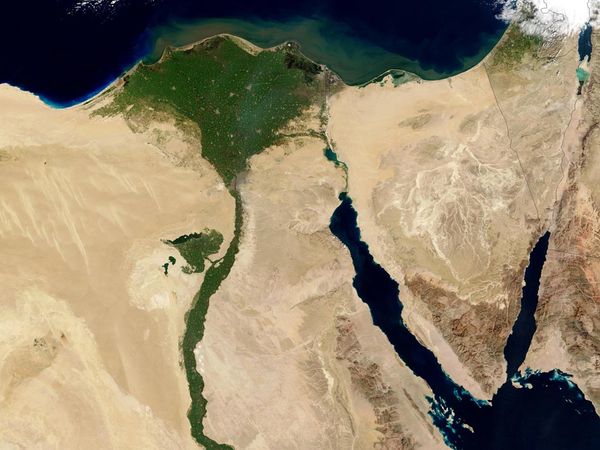
A massive canyon lays hidden below the Nile Valley in Egypt. In Part II we looked as how this massive canyon was formed. Before we go on to look a bit deeper into this canyon and how it fits into Biblical chronology lets look at the chronological sequence of historical events—according to the consensus of geological experts—that must have occurred to form the Nile River Valley that we observe today:
- The basement rock of metamorphic rock—granite—formed.
- On top of this granite hundreds of layers of sedimentary fossil-bearing rocks were deposited.
- A river formed which cut through the upper-layers of the sedimentary rock.
- The Mediterranean basin experienced periods of desiccation resulting in sea levels thousands of feet lower than today.
- As the Mediterranean sea level dropped, the Nile River eroded more deeply into the sedimentary rocks and then the granites below them.
- The Mediterranean basic rapidly refilled after being reconnected to the Atlantic Ocean resulting in the formation of a long deep lake in the Nile Valley were the canyon had been.
- Starting at the southern end of this lake the Nile River deposited sediments which started filling the lake. Eventually the lake was filled all the way up to where the Nile River delta is today.
- Only after the sediments filled the valley and the river could take a meandering path between the boundaries of the upper canyon walls did the valley itself become available for human occupation.
- The Egyptian civilization developed and the pyramids were constructed.
When did this happen and how long did it take for the Nile Valley to form?
Geologist studying the Mediterranean basin have determined that this Messinian Salinity Crisis occurred over a long period of time—6 million and 5.3 million years ago—in which sea levels in the basin where well below their current levels. The crisis came to an abrupt end around 5.3 MYA when the Straits of Gibraltar opened up allowing for the entire basin to be refilled with sea water from the Atlantic Ocean.
At this point the lake in the Nile Valley formed and filling of that lake could begin. Glen Morton, an ex-YEC advocate and professional geologists has thoroughly studied the geological literature about the Messinian Salinity Crises, has written about the problems that the Nile River creates for YECs. Regarding this filling of the Nile Valley lake after the salinity crisis I quote Morton with respect to how quickly that process could occur:
The volume of Nile sediments in the canyon (determined by measuring the width and depth of the canyon from seismic data) is 200 x 10^12 cubic meters (Rushdi Said, “The Geological evolution of the River Nile,” in Fred Wendorf and Anthony E. Marks, Editors “Problems in Prehistory: North Africa and the Levant,” (Dallas: Southern Methodist University, 1975), pp 7-44, p. 15). (*see note about this figure)
The Nile River inputs 121 x 10^9 kg of material per year to the delta. That works out to be 50,500,000 cubic meters per year (121 x 10^9 kg/ 2400 kg/m^3). [see Scott M. Mclennan “Weathering and Global Denudation”, Journal of Geology, 101:2, p. 296)
Dividing these two numbers we have 3,960,396 years for the length of time it took for the Nile, with observed depositional rates to fill up the canyon. Thus the delta, which protrudes from the African coast started about 1 million years ago. The Nile has been in place for about 5 million years. This is consistent with radioactive dating of the time of formation of the canyon.
The sediment load of the river and the amount of sediments needed to fill the valley comport well with the radiometric dating of the origin of the canyon. Even if we were to grant that the Nile River had triple the water volume in the past, the massive lake in the canyon would have taken a million years to fill with sediment. This is a critical piece of data that must be explained by any view of the age of the Earth.
The Nile Valley canyon is not unique
As surprising as finding a massive canyon below the Nile Valley may be this is not the only buried canyon in this part of the world. All of the other major rivers that empty into the Mediterranean Sea sit on top of buried canyons though none so far have been shown to be as large as the Nile Valley canyon. These canyons, which can run hundreds of miles inland and reach well below today’s sea level, offer further compelling evidence that the Mediterranean basin experienced significantly lower water levels in the distant past.
In summary…
Taken together, the salt deposits below the Mediterranean basin, massive deposits of sediments on top of those salt deposits from the cutting of the canyons in to the basin, the presence of canyons all around the Mediterranean basin, and the presence of massive sedimentary deposits with compositions that match rocks from upstream sources all point to a long history of events that led to the creation of the Nile River valley as we see it today.
Coming up…
In the next post we will ask what the lost canyon of the Nile tells us about Biblical chronology and age of the Earth. In other words, were does the Nile canyon fit in the Biblical narrative. Before I provide an answer, ask yourself what you think Abraham would have seen when he traveled to Egypt the first time? Did he set his eyes on the same wide Nile River valley that we see today? What about the Egyptian civilization, did it ever know a time when the river was anything but what it appears to be today?

* It was pointed out in the comments section that this number may be in error as it likely reflects an estimate using the sediment fan of the delta which is not reflective of the entire Nile River canyon. This results in an overestimate of total sediments and thus the time required to fill the entire canyon based on sediment imputs is overstated. However, the main point still stands that it would have taken hundreds of thousands of years to fill the entire canyon vs less than 4500 years in the YEC hypothesis.
Cover image credit: Painting, by Carlo Mancini, of the Great Pyramids on the distant shore of the Nile River. By Jean-Marc Pascolo (Own work) [CC-BY-SA-3.0 (creativecommons.o…], via Wikimedia Commons

I just want to say that I enjoy your blog immensely. Please keep them coming!
LikeLike
Agreed, Great Blog. I almost went into Geology in college, but ended up as a surgeon. Still love Geology and the geological history of the Nile is new to me and fascinating. Looking forward the the next Blog.
LikeLiked by 1 person
I enjoy your blog very much and have learned a lot from it. Just a technical quibble: I think the figure of 200 x 10^12 cubic meters (200,000 cubic km) is not the size of the canyon itself, but rather the sediment fan deposited on the seafloor at the mouth of the Nile. That in no way invalidates your calculation since the fan also had to be deposited by the Nile. But it would make the Nile canyon about 50 times bigger than the Grand Canyon, which is impossible. Assuming a length of 1,300 km and an average width of 15 km implies an average depth of 10 km, as opposed to a maximum depth of 2.5 km at the canyon mouth.
If creationists were exercising due diligence they should have pounced on this quibble long ago, but ….
Any way, thanks again for the post!
LikeLike
Sorry, I overlooked the fact that you were quoting Glenn Morton, my bad.
LikeLike
I’m glad you pointed that out though. I should look at that and maybe add a footnote at the very least.
LikeLike
Yes there are many bedrock canyons in the med sea. yes these came from powerful megafloods that suddenly poured into it. Not slow processes. this probably happened about 2200-2100BC. just allowing dry land long enough to fill up africa from the ark . then it flooded to have israels boundary. etc
the salt depositions probably come from sorting events. nOt from the Med sea drying up.
Another reason YEC desires a sudden megaflood is to explain the origin of post flood/above the k-t line, fossilization. Especially in those famous fossil beds in Egypt with those giant creatures.
LikeLike