Here is a puzzle: Where can you stand on dry ground and look up to see a river channel above you?
Yes, New Orleans is a good answer. However, I’m talking about looking up 100 feet from a non man-made location. There are many places on Earth and possibly on Mars where such river channels may be found. But I am not talking about river channels with flowing water. I am talking about “fossil” river channels.
A bit of a trick question, but a cool geological landform nonetheless. Let me introduce you to fossil riverbeds and specifically a type of fossil riverbed called an inverted paelochannel. One of the best places to see these strange landforms is in the deserts of Utah
Here I introduce you to one of these exhumed paleochannels but if you prefer to hear me talk about them in a PPT presentation click on the YouTube video below.
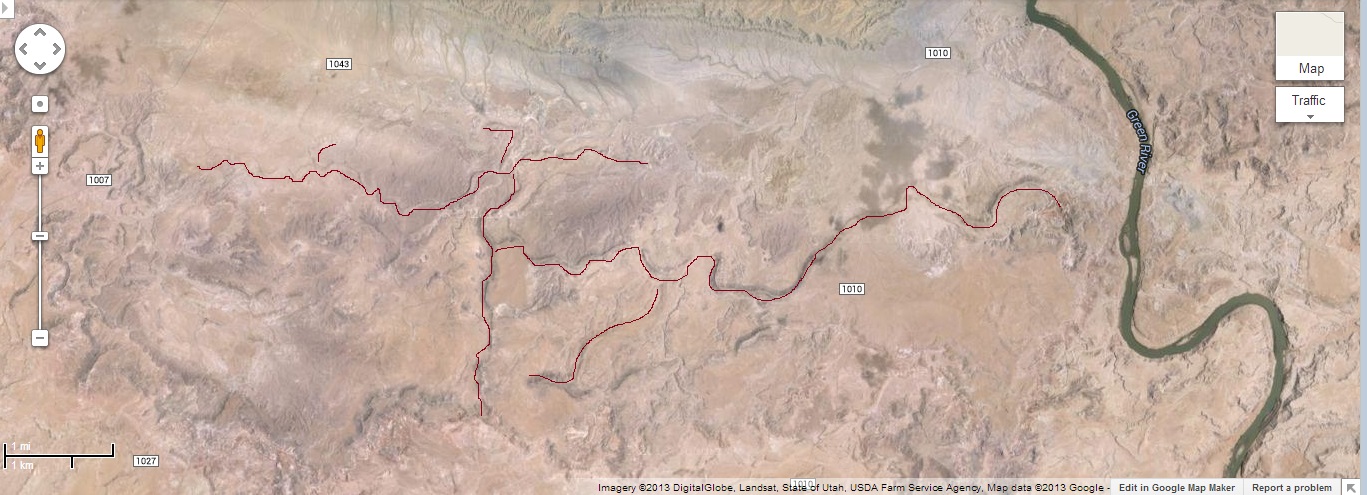
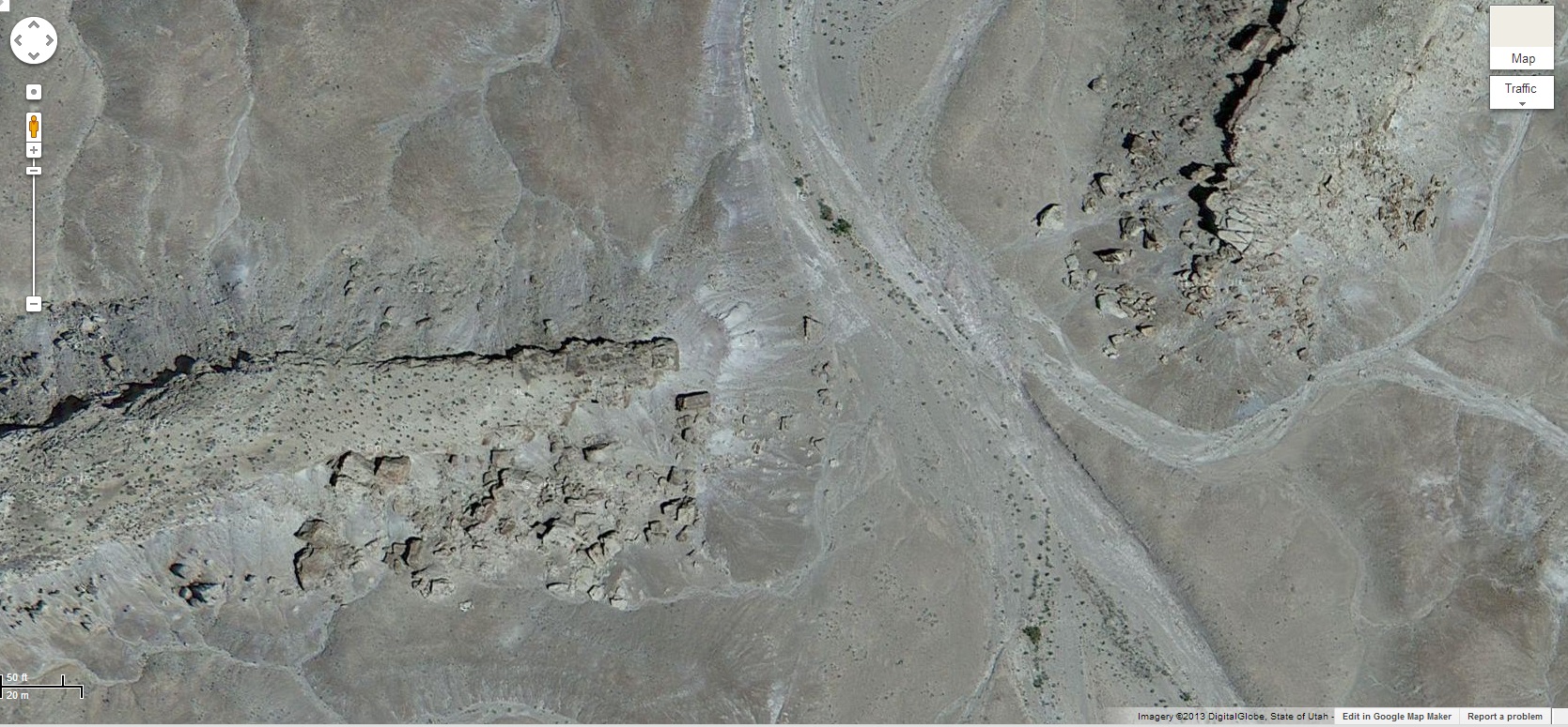
Above we see a satellite image of the desert region south of the city of Green River in south central Utah. To the right is the snaking Green River which has eroded a deep channel into the red sandstone rock. What I have outlined in this image are just some of the “fossil” rivers in the area. These fossil rivers, or preserved paleochannels, are composed of cemented gravel-capped ridges that represent the solidified remains of ancient riverbeds. What you might find most shocking about these preserved rivers is that what I have outlined are actually the highest elevations on the image. These rivers are raised up 100 feet or more above all their surroundings. Because they appear as raised ridges they have been called inverted paleochannels. Let’s look a bit closer.
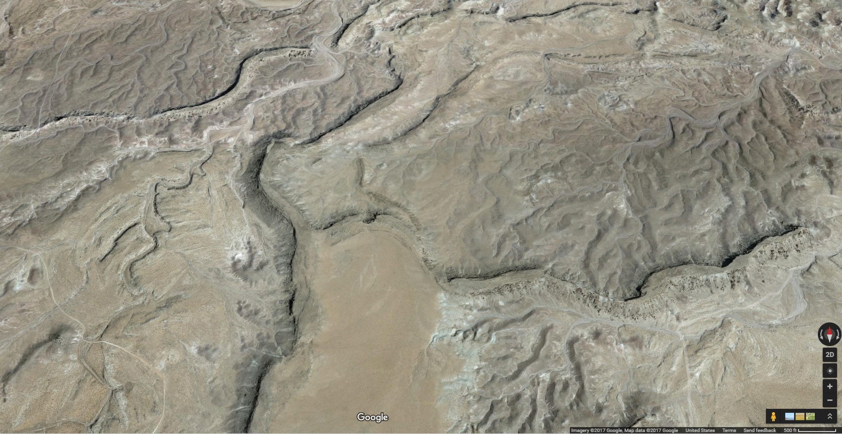
Above is a closer look at one section just a few miles long of an ancient river bed. You might be able to tell that the river is actually not in a valley but is rather the exact opposite. The river represents the highest elevations and the ground slopes away from the riverbed. I understand this is counter intuitive but these river beds really are higher than their surroundings.
Now look at the picture to the right. You can see that these sinuous ridges are just that, ridges and not valleys. While this looks like a winding river you would not be expected to believe these are the remains of rivers just looking at them. But close inspection of the rocks themselves reveals the characteristics of an ancient river.
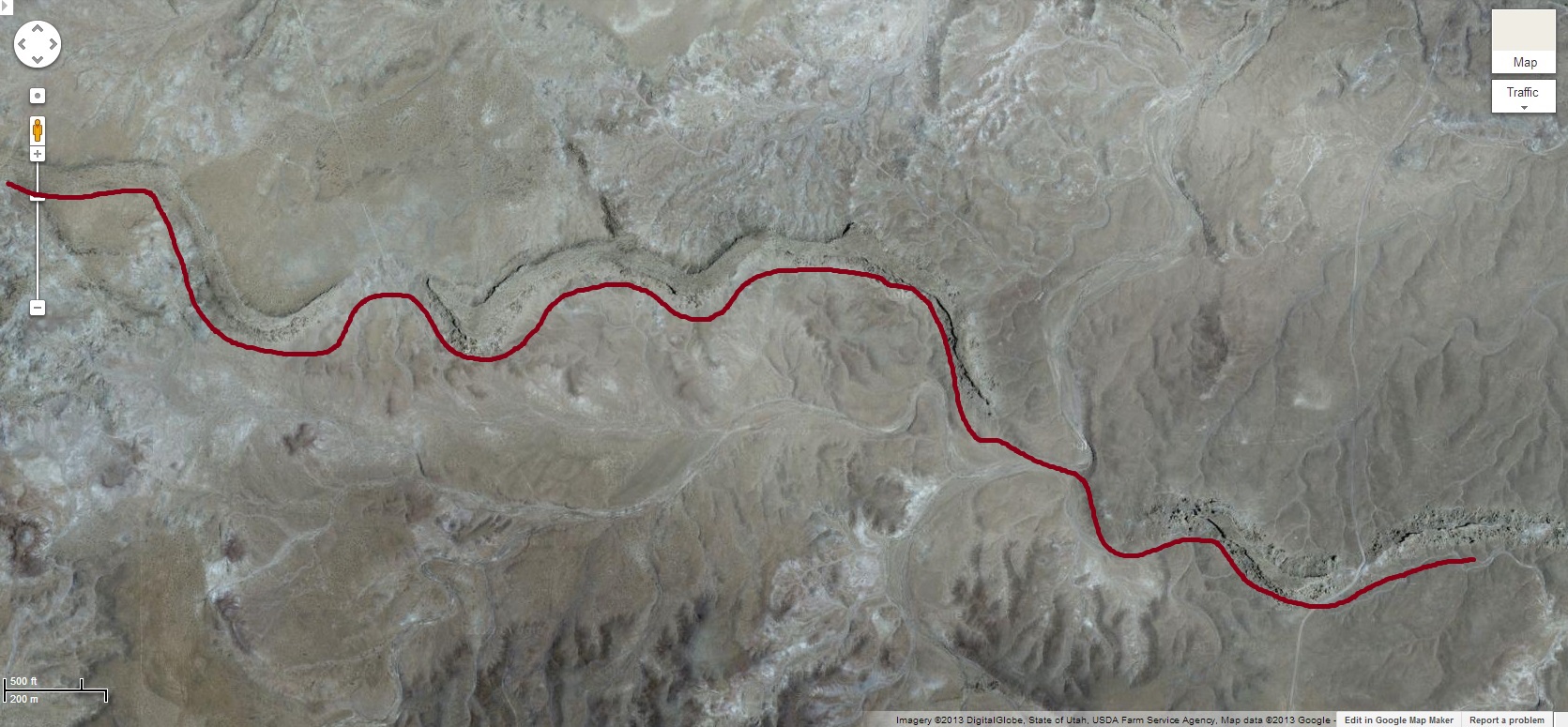
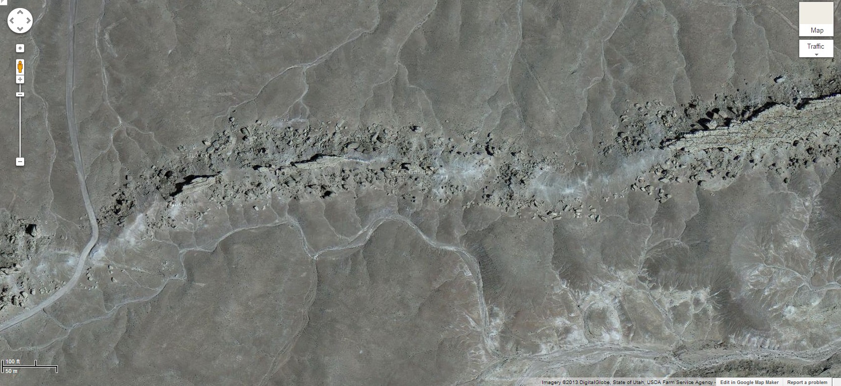
These ridges are the product of eons of erosion around the hard cap rock that resists erosion. That rock is made from cemented gravel and sand that shows all the signs of having been the bed of an ancient river system. That material in the river bed became much harder rock that the layers below or to each side and so much later when the entire area was eroded the rock of the ancient river bed resisted that erosion.
Above is an even closer view at a portion of this inverted river channel. In this case an intermittent creek has eroded a path through the ridge. You can see (click on images for larger view) the large slabs of erosion resistant rock (about 100 feet above the surrounding area) that have fallen from the ridge of hard rock. These are all rocks that are called conglomerates and are made of cemented gravel.
What is the proposed origin of these fossil riverbeds?
The time-scale and the amount of rock eroded to produce these inverted palaeochannels is quite mind-boggling. Here is the conventional geological scenario for the origins of these inverted palaeochannels:
1) Long ago in the Jurassic this region was low-lying land with gentle hills and dinosaurs roamed the area as evidenced by the many dinosaur bones preserved in these formations. Winding rivers would have run among the hills creating the channels we see today.
2) Later, a warming globe melted the ice at the poles along with other changes in the ocean floor flooding the entire region. Eventually several thousand feet of sediments were deposited over the whole region as the land sank. This buried the river valleys with sediments. Over time what had been the gravel river bottoms solidified into very hard rock made of cemented stones (conglomerates).
3) When the earth cooled combined with thrusting-up of the continental crust the entire area region was once again subject to erosion. Eventually thousands of feet of rock eroded from this whole area. When that downward erosion reached the level where these ancient rivers were the rock was resistant while what were the hills next to the rivers where not as resistant and so continued to erode. Eventually the latter eroded down further than where the river used to be. As a result what was the bottom of the rivers are now found more than 100 feet above most of the surrounding area. This is why the channels have been referred to as being “exhumed.” They have been exhumed from a state of burial for millions of years and brought back to the surface.
This process might be very difficult to image so let’s try a simpler example. Lets say we dug a foundation in a flat area of deep soil and poured concrete footers for a home. Later that home is destroyed by a flood that drags the house away and covers the area with some more sediment. If, over the next 50 years, streams erode the ground in that area eventually the footers will be revealed (exhumed to the surface) and with enough erosion will find themselves sitting above the surface because they are more resistant to erosion than the soil around them. Likewise, the riverbeds long ago became like a layer of cement in the valley floors and later when everything around them eroded they have found themselves sitting above all of their surroundings.
An analogue on Mars?
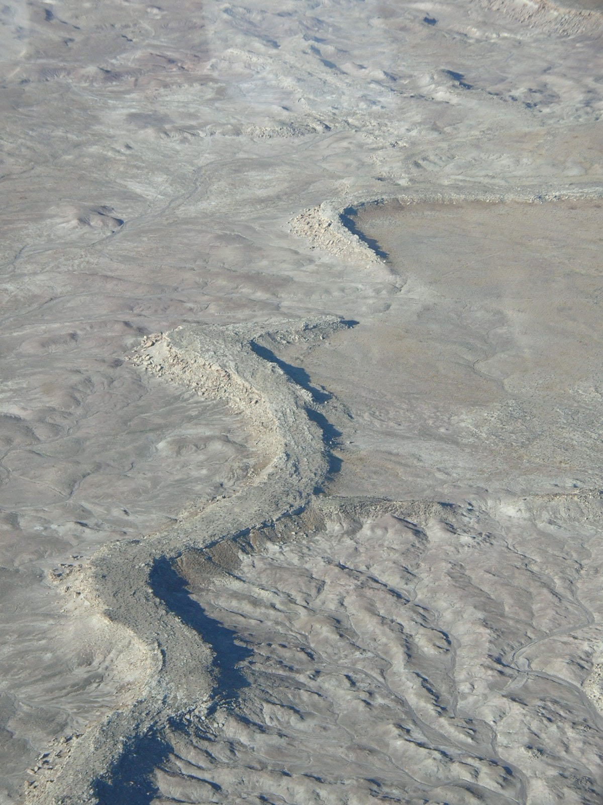
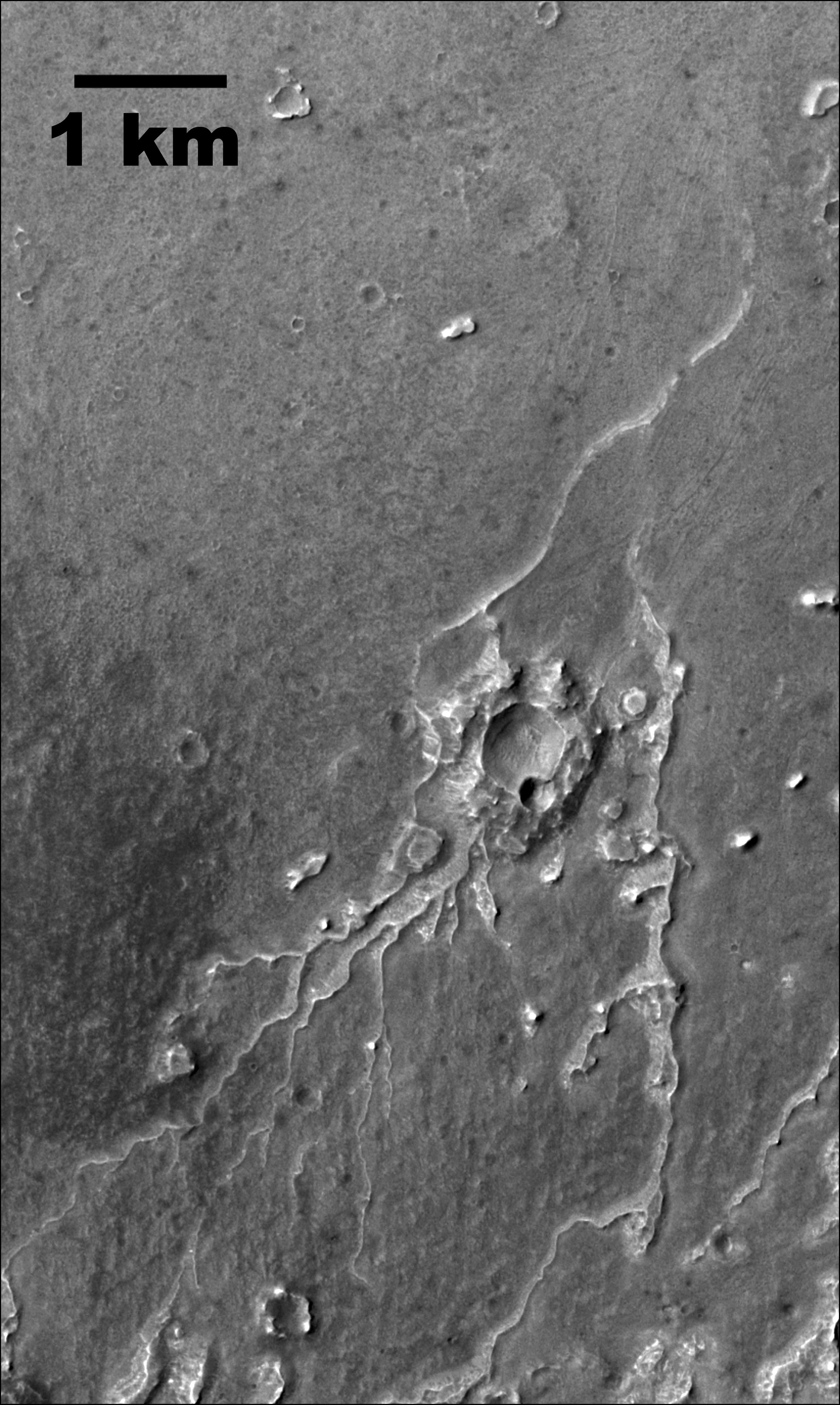
Inverted channels are not just a feature found here on Earth. It appears that there are similar raised channels on Mars. Below is an image from Mars of what appears to be the remnants of ancient stream channels. What you can’t tell from this image is that the meandering branching pattern you see are not channels eroded into the surface of Mars but are actually ridges and so represent higher elevation than the surrounding landscape. If these are fossil stream beds then these may have a similar history. On Earth we can explain the erosion of the material that buried these rivers as erosion by water but on Mars, these ancient fossil rivers must have been exposed as ridges as the result of wind as the erosive agent. On Mars this takes a long time. Features such as these inverted valleys on the Mars surface are thought to have taken a half a billion years or longer via wild erosion.
References:
Williams, R.M.E., Chidsey, T.C., Jr., and Eby, D.E., (2007), Exhumed paleochannels in central Utah – analogs for raised curvilinear features on Mars, in Willis, G.C., Hylland, M.D., Clark, D.L., and Chidsey, T.C., Jr., editors, Central Utah – diverse geology of a dynamic landscape: Utah Geological Association Publication 36, Salt Lake City, Utah, 220-235. http://www.psi.edu/sites/default/files/imported/research/reports/2007/williamspics/Williams07_UGA36.pdf
Note: This is an updated a revised article first posted in 2013

Another problem for the young earth scenario. This couldn’t have happened through a global flood.
LikeLike
Yep, it is hard to imagine how these ridges would fit into the young-earth chronology. They can’t be pre-flood rivers. They couldn’t have formed during a flood. Post-flood? Maybe they could say these were post-flood pre-ice age rivers but how did they get buried and exhumed? Where is the evidence of much wetter environments in that area after the Flood? There isn’t any.
LikeLike
For what its worth, I suspect the common run of YouTube creationist would say that these were pre-flood rivers that were filled in during the flood and then eroded by glaciation during the post-deluvian ice age. Then he would start calling you juvenile names to drown out your response.
LikeLike
The YEChies now say there was a period after the Flood in which the Earth convulsed, created all the mountains, volcanoes, canyons (besides those made in the flood), and otherwise created the Earth we see today. Conveniently, there is no evidence for this fantasy, so there is no evidence against.
LikeLike
What would evidence for that level of disturbance even look like?
LikeLike
The few discussions I have had with YEC’s have centered on the idea that nothing like the Flood (with or without subsequent convulsions) has ever been seen, so we can not know what the evidence would look like. These YEC’s have been quite comfortable with the idea that only ad hoc explanations of evidence are needed, since on a global scale, local variations of Flood conditions could have prevailed, producing unique results for any given location.
Our host and author certainly knows better than I do, but my bet is that YEC’s dismiss the exhumed paleochannels evidence as being misinterpreted. Something along the lines of, water erodes and so the idea of flowing water hardening a riverbed can not be correct. Therefore, must be a Flood effect.
LikeLiked by 1 person
About 30 years ago, I drove a highway south of Rapid City SD, parking where I could hike a few miles east to explore someone’s field – turned out to be buffalo pasture, so I retraced my steps, with less attention to spotting a rare Fairburn Agate. The point of this story is that near the road there was an outcrop of cemented grit and pebbles of every color – more easily fragmented – the rock that you so convincingly describe. This would be outside the Black Hills hogback proper – in case somebody isn’t driving as far as Utah. CK (above) might have mentioned that the fossil ecosystem of the SD Bad Lands has to be post-Flood, in the YEC dream. Not to forget the NE Nebraska Ashfall Park, another ecosystem of extinct species that had to hot-foot it from SE Turkey b-e-f-o-r-e North America slid far enough west for all of Yellowstone to be “created” post-Flood. So geht’s im Leben. GLL
LikeLike
The Nebraska ashfall, by way of national geographic, was one of the first things that ever interested me about origins. indeed that ashfall must be post flood and around 2100BC to 1900BC.
These critters had time to get there .The bad lands are bad because of the volcanic eruptions destroying the area. i think these were from the continent rising/dropping in jerks and the origin for this fossilized river as opposed to a pre flood river fossiled by the flood sediment.
LikeLike
You really don’t see your control of comments here is just out of control, do you? I cannot believe somebody wastes so much time on base criticism of such a tiny topic and only wants to post comments that are a celebration on you or your view.
I wish you peace.
LikeLike
Not sure what you are referring to with respect to “out of control.” They are moderated but it only means that I see them before they are posted to be sure they are not just spamming. I’m on vacation and so I could take a few hours to a few days to approve comments.
LikeLike
As a creationist I love these type of things. It does seem to be post flood. So it fits in with a need for YEC to have the coninents jumping up and down a few centuries afterr the flood. for many reasons. so this river would be living and then the continent was raised and that week the sediment load moving from this event would fossilize it and remove the neighbouring depth of rock. there are other instances of this. another thing is how marine mammals are found stranded way high in S america.
remember. Creationism needs to drown the areas around the continents to have stopped fauna/flora migration. before the ice age. likewise to carve out the mexican gulf.
LikeLike